Trasaghis geodata
Trasaghis (Friuli Venezia Giulia) is a seat of a third-order administrative division; located in Italy in Europe/Rome (GMT+2) time zone. With population of 469 people, there are 10026 cities with bigger population in this country. Compared to other cities in Italy, 96.7% of cities are located further ↓South; 69.1% of cities are located further ←West and 56.4% of cities have higher elevation than Trasaghis. Note1
Administrative division(s):
- Level 1: Friuli Venezia Giulia
- Level 2: Provincia di Udine
- Level 3: Trasaghis


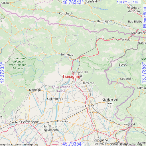
Trasaghis GPS coordinates[2]
46° 16' 53.904" North, 13° 4' 31.62" East
| Map corner | latitude | longitude |
|---|---|---|
| Upper-left | 46.76543°, | 12.37233° |
| Center: | 46.28164°, | 13.07545° |
| Lower-right: | 45.79354°, | 13.77858° |
| Map W x H: | 108.1×108.1 km | = 67.2×67.2mi |
| max Lat: | 47.04031° ⇑3.3% North |
| Trasaghis: | 46.28164° |
| min Lat: | ⇓96.7% South 35.50142° |
| min Long | Trasaghis | max Long |
| 6.69888° | 13.07545° | 18.48682° |
| W 69.1%⇐ | ⇒30.9% E |
Elevation
Elevation of Trasaghis is 192 m = 630 ft, and this is 114.7 m = 376 ft below average elevation for this country.
| Max E: |
2085 m = 6841 ft | 56.4% |
| Avg. | 306.7 m = 1006 ft | |
| Trasaghis | 192 m = 630 ft | |
Min E: |
-4 m = -13 ft | 43.6% |
See also: Italy elevation on elevation.city.
Geographical zone
Trasaghis is located in North temperate zone (between Tropic of Cancer and the Arctic Circle). Distance of this North polar circle is 2255.1 km =1401.3 mi to North.| Distance of | km | miles | from Trasaghis |
|---|---|---|---|
| North Pole | 4861 | 3020.5 | to North |
| Arctic Circle | 2255.1 | 1401.3 | to North |
| Tropic Cancer | 2540.1 | 1578.3 | to South |
| Equator | 5146 | 3197.6 | to South |


Nearby cities:
15 places around Trasaghis: (largest is in red/bold)
• Alesso
4.2 km =2.6 mi,  336°
336°
• Amaro
10.3 km =6.4 mi,  7°
7°
• Anduins
10.5 km =6.5 mi,  239°
239°
• Artegna
7.7 km =4.8 mi,  127°
127°
• Bordano
4.4 km =2.7 mi,  31°
31°
• Buia
8.4 km =5.2 mi,  157°
157°
• Cavazzo Carnico
10 km =6.2 mi, 344°
• Forgaria nel Friuli
10.3 km =6.4 mi,  228°
228°
• Gemona
3.7 km =2.3 mi,  103°
103°
• Isola
8.5 km =5.3 mi,  109°
109°
• Majano
10.5 km =6.5 mi,  185°
185°
• Montenars
8 km =5 mi,  115°
115°
• Osoppo
3 km =1.9 mi,  166°
166°
• Santo Stefano
9 km =5.6 mi,  154°
154°
• Venzone
7.2 km =4.5 mi,  41°
41°
Sources, notices
• [Note1] Compared only with cities in Italy existing in our database
• [Src1] Map data: © OpenStreetMap contributors (CC-BY-SA)
• [Src2] Other city data from geonames.org with taken over terms of usage.
• [Src3] Geographical zone / Annual Mean Temperature by Robert A. Rohde @ Wikipedia
