Tramutola geodata
Tramutola (Basilicate) is a seat of a third-order administrative division; located in Italy in Europe/Rome (GMT+2) time zone. With population of 2,388 people, there are 3651 cities with bigger population in this country. Compared to other cities in Italy, 85.4% of cities are located further ↑North; 91.7% of cities are located further ←West and 87.2% of cities have lower elevation than Tramutola. Note1


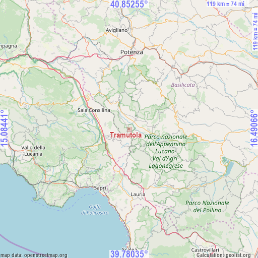
Tramutola GPS coordinates[2]
40° 19' 6.888" North, 15° 47' 15.108" East
| Map corner | latitude | longitude |
|---|---|---|
| Upper-left | 40.85255°, | 15.08441° |
| Center: | 40.31858°, | 15.78753° |
| Lower-right: | 39.78035°, | 16.49066° |
| Map W x H: | 119.2×119.2 km | = 74.1×74.1mi |
| max Lat: | 47.04031° ⇑85.4% North |
| Tramutola: | 40.31858° |
| min Lat: | ⇓14.6% South 35.50142° |
| min Long | Tramutola | max Long |
| 6.69888° | 15.78753° | 18.48682° |
| W 91.7%⇐ | ⇒8.3% E |
Elevation
Elevation of Tramutola is 657 m = 2156 ft, and this is 350.3 m = 1149 ft above average elevation for this country.
| Max E: |
2085 m = 6841 ft | 12.8% |
| Tramutola | 657 m 2156 ft | |
| Avg. | 306.7 m = 1006 ft | |
Min E: |
-4 m = -13 ft | 87.2% |
See also: Italy elevation on elevation.city.
Geographical zone
Tramutola is located in North temperate zone (between Tropic of Cancer and the Arctic Circle). Distance of this Northern Tropic circle is 1877.1 km =1166.4 mi to South.| Distance of | km | miles | from Tramutola |
|---|---|---|---|
| North Pole | 5524.1 | 3432.5 | to North |
| Arctic Circle | 2918.2 | 1813.3 | to North |
| Tropic Cancer | 1877.1 | 1166.4 | to South |
| Equator | 4483 | 2785.6 | to South |


Nearby cities:
15 places around Tramutola: (largest is in red/bold)
• Arenabianca
8.6 km =5.3 mi,  252°
252°
• Cessuta
7.2 km =4.5 mi,  183°
183°
• Grumento Nova
9.5 km =5.9 mi,  114°
114°
• Magorno
6 km =3.7 mi,  217°
217°
• Marsicovetere
7.1 km =4.4 mi,  26°
26°
• Moliterno
10.6 km =6.6 mi,  141°
141°
• Montesano sulla Marcellana
8.5 km =5.3 mi,  236°
236°
• Padula
11.3 km =7 mi,  281°
281°
• Paterno
7.7 km =4.8 mi,  324°
324°
• Prato Comune
9.7 km =6 mi, 241°
• Sarconi
11.6 km =7.2 mi,  132°
132°
• Tardiano
7.9 km =4.9 mi,  205°
205°
• Tempa la Mandra
10.6 km =6.6 mi, 254°
• Viggiano
9.9 km =6.2 mi,  74°
74°
• Villa d'Agri
5.2 km =3.2 mi,  40°
40°
Sources, notices
• [Note1] Compared only with cities in Italy existing in our database
• [Src1] Map data: © OpenStreetMap contributors (CC-BY-SA)
• [Src2] Other city data from geonames.org with taken over terms of usage.
• [Src3] Geographical zone / Annual Mean Temperature by Robert A. Rohde @ Wikipedia
