Magorno geodata
Magorno (Campania) is a populated place; located in Italy in Europe/Rome (GMT+2) time zone. With population of 624 people, there are 8809 cities with bigger population in this country. Compared to other cities in Italy, 85.8% of cities are located further ↑North; 91.5% of cities are located further ←West and 94.2% of cities have lower elevation than Magorno. Note1
Administrative division(s):
- Level 1: Campania
- Level 2: Provincia di Salerno
- Level 3: Montesano sulla Marcellana


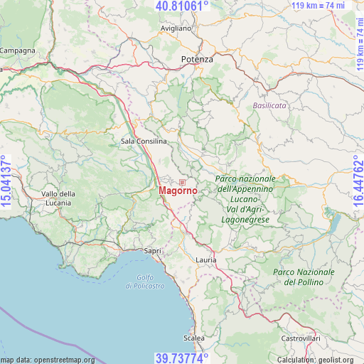
Magorno GPS coordinates[2]
40° 16' 34.68" North, 15° 44' 40.164" East
| Map corner | latitude | longitude |
|---|---|---|
| Upper-left | 40.81061°, | 15.04137° |
| Center: | 40.2763°, | 15.74449° |
| Lower-right: | 39.73774°, | 16.44762° |
| Map W x H: | 119.3×119.3 km | = 74.1×74.1mi |
| max Lat: | 47.04031° ⇑85.8% North |
| Magorno: | 40.2763° |
| min Lat: | ⇓14.2% South 35.50142° |
| min Long | Magorno | max Long |
| 6.69888° | 15.74449° | 18.48682° |
| W 91.5%⇐ | ⇒8.5% E |
Elevation
Elevation of Magorno is 845 m = 2772 ft, and this is 538.3 m = 1766 ft above average elevation for this country.
| Max E: |
2085 m = 6841 ft | 5.8% |
| Magorno | 845 m 2772 ft | |
| Avg. | 306.7 m = 1006 ft | |
Min E: |
-4 m = -13 ft | 94.2% |
See also: Italy elevation on elevation.city.
Geographical zone
Magorno is located in North temperate zone (between Tropic of Cancer and the Arctic Circle). Distance of this Northern Tropic circle is 1872.4 km =1163.5 mi to South.| Distance of | km | miles | from Magorno |
|---|---|---|---|
| North Pole | 5528.8 | 3435.4 | to North |
| Arctic Circle | 2922.9 | 1816.2 | to North |
| Tropic Cancer | 1872.4 | 1163.5 | to South |
| Equator | 4478.3 | 2782.7 | to South |


Nearby cities:
15 places around Magorno: (largest is in red/bold)
• Arenabianca
5.1 km =3.2 mi,  295°
295°
• Buonabitacolo
10.5 km =6.5 mi,  265°
265°
• Casalbuono
8.4 km =5.2 mi,  215°
215°
• Cessuta
4.1 km =2.5 mi,  127°
127°
• Grumento Nova
12.3 km =7.6 mi,  86°
86°
• Moliterno
10.9 km =6.8 mi,  109°
109°
• Montesano Scalo
7.3 km =4.5 mi, 274°
• Montesano sulla Marcellana
3.4 km =2.1 mi, 269°
• Padula
10.2 km =6.3 mi,  313°
313°
• Paterno
11 km =6.8 mi,  355°
355°
• Prato Comune
4.9 km =3 mi, 271°
• Tardiano
2.5 km =1.6 mi,  173°
173°
• Tempa la Mandra
6.8 km =4.2 mi,  286°
286°
• Tramutola
6 km =3.7 mi,  37°
37°
• Villa d'Agri
11.2 km =7 mi, 39°
Sources, notices
• [Note1] Compared only with cities in Italy existing in our database
• [Src1] Map data: © OpenStreetMap contributors (CC-BY-SA)
• [Src2] Other city data from geonames.org with taken over terms of usage.
• [Src3] Geographical zone / Annual Mean Temperature by Robert A. Rohde @ Wikipedia
