Padula geodata
Padula (Campania) is a seat of a third-order administrative division; located in Italy in Europe/Rome (GMT+1) time zone. With population of 2,688 people, there are 3319 cities with bigger population in this country. Compared to other cities in Italy, 85.3% of cities are located further ↑North; 91.1% of cities are located further ←West and 84.7% of cities have lower elevation than Padula. Note1


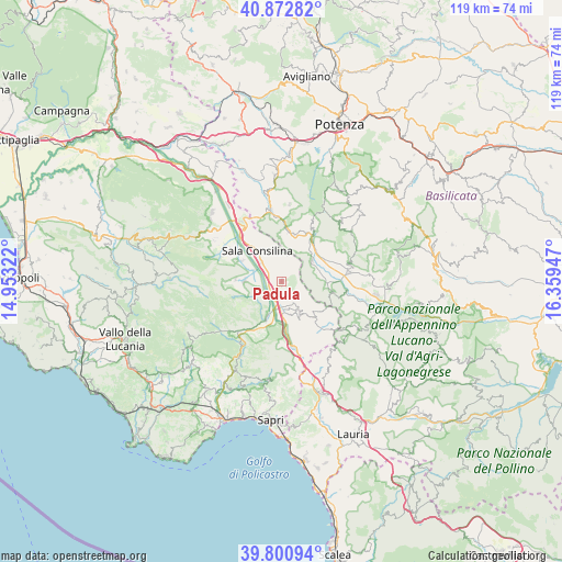
Padula GPS coordinates[2]
40° 20' 20.436" North, 15° 39' 22.824" East
| Map corner | latitude | longitude |
|---|---|---|
| Upper-left | 40.87282°, | 14.95322° |
| Center: | 40.33901°, | 15.65634° |
| Lower-right: | 39.80094°, | 16.35947° |
| Map W x H: | 119.2×119.2 km | = 74.1×74.1mi |
| max Lat: | 47.04031° ⇑85.3% North |
| Padula: | 40.33901° |
| min Lat: | ⇓14.7% South 35.50142° |
| min Long | Padula | max Long |
| 6.69888° | 15.65634° | 18.48682° |
| W 91.1%⇐ | ⇒8.9% E |
Elevation
Elevation of Padula is 604 m = 1982 ft, and this is 297.3 m = 975 ft above average elevation for this country.
| Max E: |
2085 m = 6841 ft | 15.3% |
| Padula | 604 m 1982 ft | |
| Avg. | 306.7 m = 1006 ft | |
Min E: |
-4 m = -13 ft | 84.7% |
See also: Italy elevation on elevation.city.
Geographical zone
Padula is located in North temperate zone (between Tropic of Cancer and the Arctic Circle). Distance of this Northern Tropic circle is 1879.4 km =1167.8 mi to South.| Distance of | km | miles | from Padula |
|---|---|---|---|
| North Pole | 5521.8 | 3431.1 | to North |
| Arctic Circle | 2915.9 | 1811.9 | to North |
| Tropic Cancer | 1879.4 | 1167.8 | to South |
| Equator | 4485.3 | 2787 | to South |


Nearby cities:
15 places around Padula: (largest is in red/bold)
• Arenabianca
5.6 km =3.5 mi,  148°
148°
• Buonabitacolo
8.4 km =5.2 mi,  200°
200°
• Magorno
10.2 km =6.3 mi,  133°
133°
• Monte San Giacomo
9.7 km =6 mi,  273°
273°
• Montesano Scalo
6.4 km =4 mi,  178°
178°
• Montesano sulla Marcellana
8.1 km =5 mi, 150°
• Paterno
7.8 km =4.8 mi,  59°
59°
• Prato Comune
7.4 km =4.6 mi,  159°
159°
• Sala Consilina
8.8 km =5.5 mi,  321°
321°
• Sassano
7.7 km =4.8 mi, 271°
• Silla
6.4 km =4 mi,  292°
292°
• Teggiano-Macchiaroli
10.8 km =6.7 mi, 294°
• Tempa la Mandra
5.2 km =3.2 mi,  169°
169°
• Tramutola
11.3 km =7 mi,  101°
101°
• Varco Notar Ercole
5.1 km =3.2 mi,  279°
279°
Sources, notices
• [Note1] Compared only with cities in Italy existing in our database
• [Src1] Map data: © OpenStreetMap contributors (CC-BY-SA)
• [Src2] Other city data from geonames.org with taken over terms of usage.
• [Src3] Geographical zone / Annual Mean Temperature by Robert A. Rohde @ Wikipedia
