Torviscosa geodata
Torviscosa (Friuli Venezia Giulia) is a seat of a third-order administrative division; located in Italy in Europe/Rome (GMT+2) time zone. With population of 1,886 people, there are 4344 cities with bigger population in this country. Compared to other cities in Italy, 86.8% of cities are located further ↓South; 71.2% of cities are located further ←West and 98.4% of cities have higher elevation than Torviscosa. Note1
Administrative division(s):
- Level 1: Friuli Venezia Giulia
- Level 2: Provincia di Udine
- Level 3: Torviscosa


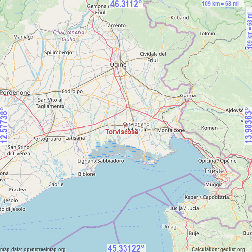
Torviscosa GPS coordinates[2]
45° 49' 24.132" North, 13° 16' 49.8" East
| Map corner | latitude | longitude |
|---|---|---|
| Upper-left | 46.3112°, | 12.57738° |
| Center: | 45.82337°, | 13.2805° |
| Lower-right: | 45.33122°, | 13.98363° |
| Map W x H: | 109×109 km | = 67.7×67.7mi |
| max Lat: | 47.04031° ⇑13.2% North |
| Torviscosa: | 45.82337° |
| min Lat: | ⇓86.8% South 35.50142° |
| min Long | Torviscosa | max Long |
| 6.69888° | 13.2805° | 18.48682° |
| W 71.2%⇐ | ⇒28.8% E |
Elevation
Elevation of Torviscosa is 3 m = 10 ft, and this is 303.7 m = 996 ft below average elevation for this country.
| Max E: |
2085 m = 6841 ft | 98.4% |
| Avg. | 306.7 m = 1006 ft | |
| Torviscosa | 3 m = 10 ft | |
Min E: |
-4 m = -13 ft | 1.6% |
See also: Italy elevation on elevation.city.
Geographical zone
Torviscosa is located in North temperate zone (between Tropic of Cancer and the Arctic Circle). Distance of this North polar circle is 2306.1 km =1432.9 mi to North.| Distance of | km | miles | from Torviscosa |
|---|---|---|---|
| North Pole | 4912 | 3052.2 | to North |
| Arctic Circle | 2306.1 | 1432.9 | to North |
| Tropic Cancer | 2489.2 | 1546.7 | to South |
| Equator | 5095.1 | 3165.9 | to South |


Nearby cities:
15 places around Torviscosa: (largest is in red/bold)
• Aiello del Friuli
8.3 km =5.2 mi,  48°
48°
• Aquileia
9.1 km =5.7 mi,  132°
132°
• Bagnaria Arsa
6.7 km =4.2 mi,  3°
3°
• Carlino
7.5 km =4.7 mi,  252°
252°
• Castions delle Mura
3 km =1.9 mi,  30°
30°
• Cervignano del Friuli
4.6 km =2.9 mi,  93°
93°
• Gonars
8.7 km =5.4 mi,  341°
341°
• Perteole
8.6 km =5.3 mi,  68°
68°
• Porpetto
6.2 km =3.9 mi,  307°
307°
• San Giorgio di Nogaro
5.4 km =3.4 mi,  274°
274°
• Sevegliano
7.4 km =4.6 mi,  15°
15°
• Strassoldo
4.9 km =3 mi,  40°
40°
• Terzo d'Aquileia
5.4 km =3.4 mi,  118°
118°
• Villa Vicentina
8.8 km =5.5 mi,  96°
96°
• Visco
9.3 km =5.8 mi, 34°
Sources, notices
• [Note1] Compared only with cities in Italy existing in our database
• [Src1] Map data: © OpenStreetMap contributors (CC-BY-SA)
• [Src2] Other city data from geonames.org with taken over terms of usage.
• [Src3] Geographical zone / Annual Mean Temperature by Robert A. Rohde @ Wikipedia
