Gonars geodata
Gonars (Friuli Venezia Giulia) is a seat of a third-order administrative division; located in Italy in Europe/Rome (GMT+2) time zone. With population of 3,938 people, there are 2428 cities with bigger population in this country. Compared to other cities in Italy, 89.2% of cities are located further ↓South; 70.8% of cities are located further ←West and 88.3% of cities have higher elevation than Gonars. Note1
Administrative division(s):
- Level 1: Friuli Venezia Giulia
- Level 2: Provincia di Udine
- Level 3: Gonars


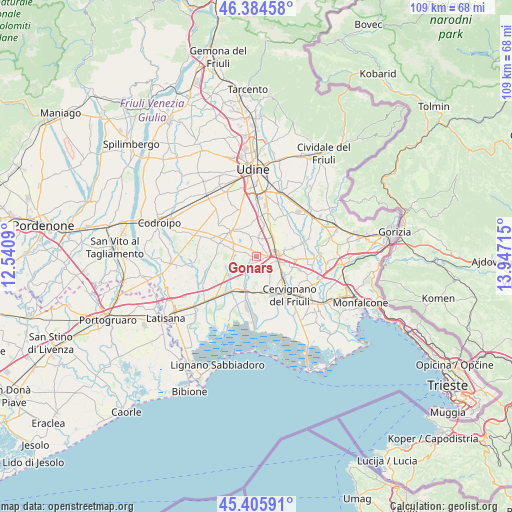
Gonars GPS coordinates[2]
45° 53' 50.64" North, 13° 14' 38.472" East
| Map corner | latitude | longitude |
|---|---|---|
| Upper-left | 46.38458°, | 12.5409° |
| Center: | 45.8974°, | 13.24402° |
| Lower-right: | 45.40591°, | 13.94715° |
| Map W x H: | 108.8×108.8 km | = 67.6×67.6mi |
| max Lat: | 47.04031° ⇑10.8% North |
| Gonars: | 45.8974° |
| min Lat: | ⇓89.2% South 35.50142° |
| min Long | Gonars | max Long |
| 6.69888° | 13.24402° | 18.48682° |
| W 70.8%⇐ | ⇒29.2% E |
Elevation
Elevation of Gonars is 22 m = 72 ft, and this is 284.7 m = 934 ft below average elevation for this country.
| Max E: |
2085 m = 6841 ft | 88.3% |
| Avg. | 306.7 m = 1006 ft | |
| Gonars | 22 m = 72 ft | |
Min E: |
-4 m = -13 ft | 11.7% |
See also: Italy elevation on elevation.city.
Geographical zone
Gonars is located in North temperate zone (between Tropic of Cancer and the Arctic Circle). Distance of this North polar circle is 2297.9 km =1427.8 mi to North.| Distance of | km | miles | from Gonars |
|---|---|---|---|
| North Pole | 4903.7 | 3047 | to North |
| Arctic Circle | 2297.9 | 1427.8 | to North |
| Tropic Cancer | 2497.4 | 1551.8 | to South |
| Equator | 5103.3 | 3171 | to South |


Nearby cities:
15 places around Gonars: (largest is in red/bold)
• Bagnaria Arsa
3.6 km =2.2 mi,  115°
115°
• Bicinicco
3.9 km =2.4 mi,  10°
10°
• Castions delle Mura
7.1 km =4.4 mi,  142°
142°
• Castions di Strada
5.1 km =3.2 mi,  289°
289°
• Felettis
2.5 km =1.6 mi,  32°
32°
• Ialmicco
8.1 km =5 mi,  77°
77°
• Lavariano
6.6 km =4.1 mi,  349°
349°
• Mortegliano
7.7 km =4.8 mi,  314°
314°
• Palmanova
5.2 km =3.2 mi, 80°
• Porpetto
5 km =3.1 mi,  204°
204°
• Santa Maria la Longa
5.4 km =3.4 mi,  40°
40°
• Sevegliano
4.9 km =3 mi,  103°
103°
• Sottoselva
6.4 km =4 mi, 75°
• Strassoldo
7.5 km =4.7 mi,  126°
126°
• Visco
8.1 km =5 mi,  94°
94°
Sources, notices
• [Note1] Compared only with cities in Italy existing in our database
• [Src1] Map data: © OpenStreetMap contributors (CC-BY-SA)
• [Src2] Other city data from geonames.org with taken over terms of usage.
• [Src3] Geographical zone / Annual Mean Temperature by Robert A. Rohde @ Wikipedia
