Toro geodata
Toro (Molise) is a seat of a third-order administrative division; located in Italy in Europe/Rome (GMT+2) time zone. With population of 1,072 people, there are 6395 cities with bigger population in this country. Compared to other cities in Italy, 74.2% of cities are located further ↑North; 85% of cities are located further ←West and 83.1% of cities have lower elevation than Toro. Note1


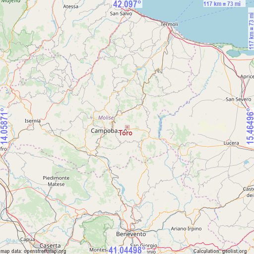
Toro GPS coordinates[2]
41° 34' 23.268" North, 14° 45' 42.588" East
| Map corner | latitude | longitude |
|---|---|---|
| Upper-left | 42.097°, | 14.05871° |
| Center: | 41.57313°, | 14.76183° |
| Lower-right: | 41.04498°, | 15.46496° |
| Map W x H: | 117×117 km | = 72.7×72.7mi |
| max Lat: | 47.04031° ⇑74.2% North |
| Toro: | 41.57313° |
| min Lat: | ⇓25.8% South 35.50142° |
| min Long | Toro | max Long |
| 6.69888° | 14.76183° | 18.48682° |
| W 85%⇐ | ⇒15% E |
Elevation
Elevation of Toro is 573 m = 1880 ft, and this is 266.3 m = 874 ft above average elevation for this country.
| Max E: |
2085 m = 6841 ft | 16.9% |
| Toro | 573 m 1880 ft | |
| Avg. | 306.7 m = 1006 ft | |
Min E: |
-4 m = -13 ft | 83.1% |
See also: Italy elevation on elevation.city.
Geographical zone
Toro is located in North temperate zone (between Tropic of Cancer and the Arctic Circle). Distance of this Northern Tropic circle is 2016.6 km =1253.1 mi to South.| Distance of | km | miles | from Toro |
|---|---|---|---|
| North Pole | 5384.6 | 3345.8 | to North |
| Arctic Circle | 2778.7 | 1726.6 | to North |
| Tropic Cancer | 2016.6 | 1253.1 | to South |
| Equator | 4622.5 | 2872.3 | to South |


Nearby cities:
15 places around Toro: (largest is in red/bold)
• Campobasso
8 km =5 mi,  259°
259°
• Campodipietra
2.3 km =1.4 mi,  219°
219°
• Campolieto
6.7 km =4.2 mi,  3°
3°
• Ferrazzano
8.8 km =5.5 mi,  237°
237°
• Gildone
7.4 km =4.6 mi,  194°
194°
• Iontapede
9 km =5.6 mi,  287°
287°
• Jelsi
6.9 km =4.3 mi,  154°
154°
• Matrice
6.7 km =4.2 mi,  319°
319°
• Mimosa-Poggio Verde-Nuova Comunità
8.6 km =5.3 mi, 243°
• Mirabello Sannitico
9.7 km =6 mi,  229°
229°
• Monacilioni
5.8 km =3.6 mi,  43°
43°
• Pietracatella
9.3 km =5.8 mi,  84°
84°
• Ripalimosani
9.2 km =5.7 mi,  296°
296°
• S.Antonio dei Lazzari
7.6 km =4.7 mi,  272°
272°
• San Giovanni in Galdo
2.2 km =1.4 mi,  337°
337°
Sources, notices
• [Note1] Compared only with cities in Italy existing in our database
• [Src1] Map data: © OpenStreetMap contributors (CC-BY-SA)
• [Src2] Other city data from geonames.org with taken over terms of usage.
• [Src3] Geographical zone / Annual Mean Temperature by Robert A. Rohde @ Wikipedia
