Pietracatella geodata
Pietracatella (Molise) is a seat of a third-order administrative division; located in Italy in Europe/Rome (GMT+2) time zone. With population of 1,261 people, there are 5754 cities with bigger population in this country. Compared to other cities in Italy, 74.1% of cities are located further ↑North; 86.2% of cities are located further ←West and 88.4% of cities have lower elevation than Pietracatella. Note1


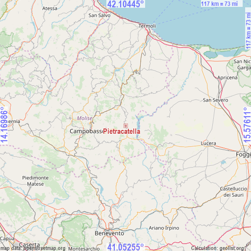
Pietracatella GPS coordinates[2]
41° 34' 50.304" North, 14° 52' 22.728" East
| Map corner | latitude | longitude |
|---|---|---|
| Upper-left | 42.10445°, | 14.16986° |
| Center: | 41.58064°, | 14.87298° |
| Lower-right: | 41.05255°, | 15.57611° |
| Map W x H: | 117×117 km | = 72.7×72.7mi |
| max Lat: | 47.04031° ⇑74.1% North |
| Pietracatella: | 41.58064° |
| min Lat: | ⇓25.9% South 35.50142° |
| min Long | Pietracatella | max Long |
| 6.69888° | 14.87298° | 18.48682° |
| W 86.2%⇐ | ⇒13.8% E |
Elevation
Elevation of Pietracatella is 679 m = 2228 ft, and this is 372.3 m = 1221 ft above average elevation for this country.
| Max E: |
2085 m = 6841 ft | 11.6% |
| Pietracatella | 679 m 2228 ft | |
| Avg. | 306.7 m = 1006 ft | |
Min E: |
-4 m = -13 ft | 88.4% |
See also: Italy elevation on elevation.city.
Geographical zone
Pietracatella is located in North temperate zone (between Tropic of Cancer and the Arctic Circle). Distance of this Northern Tropic circle is 2017.4 km =1253.6 mi to South.| Distance of | km | miles | from Pietracatella |
|---|---|---|---|
| North Pole | 5383.7 | 3345.3 | to North |
| Arctic Circle | 2777.8 | 1726 | to North |
| Tropic Cancer | 2017.4 | 1253.6 | to South |
| Equator | 4623.3 | 2872.8 | to South |


Nearby cities:
15 places around Pietracatella: (largest is in red/bold)
• Campodipietra
11 km =6.8 mi,  256°
256°
• Campolieto
10.6 km =6.6 mi,  303°
303°
• Carlantino
8.8 km =5.5 mi,  80°
80°
• Celenza Valfortore
9.1 km =5.7 mi,  104°
104°
• Colletorto
12 km =7.5 mi,  41°
41°
• Gambatesa
8.7 km =5.4 mi,  157°
157°
• Jelsi
9.4 km =5.8 mi,  221°
221°
• Macchia Valfortore
3.6 km =2.2 mi,  64°
64°
• Monacilioni
6.2 km =3.9 mi, 302°
• Riccia
11.4 km =7.1 mi,  197°
197°
• San Giovanni in Galdo
10.1 km =6.3 mi,  276°
276°
• San Marco la Catola
12.7 km =7.9 mi,  119°
119°
• Sant'Elia a Pianisi
4.4 km =2.7 mi,  2°
2°
• Toro
9.3 km =5.8 mi, 264°
• Tufara
12.6 km =7.8 mi,  150°
150°
Sources, notices
• [Note1] Compared only with cities in Italy existing in our database
• [Src1] Map data: © OpenStreetMap contributors (CC-BY-SA)
• [Src2] Other city data from geonames.org with taken over terms of usage.
• [Src3] Geographical zone / Annual Mean Temperature by Robert A. Rohde @ Wikipedia
