Campolieto geodata
Campolieto (Molise) is a seat of a third-order administrative division; located in Italy in Europe/Rome (GMT+2) time zone. With population of 629 people, there are 8780 cities with bigger population in this country. Compared to other cities in Italy, 73.6% of cities are located further ↑North; 85.1% of cities are located further ←West and 90.4% of cities have lower elevation than Campolieto. Note1


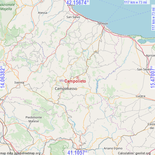
Campolieto GPS coordinates[2]
41° 38' 0.096" North, 14° 46' 0.984" East
| Map corner | latitude | longitude |
|---|---|---|
| Upper-left | 42.15674°, | 14.06382° |
| Center: | 41.63336°, | 14.76694° |
| Lower-right: | 41.1057°, | 15.47007° |
| Map W x H: | 116.9×116.9 km | = 72.6×72.6mi |
| max Lat: | 47.04031° ⇑73.6% North |
| Campolieto: | 41.63336° |
| min Lat: | ⇓26.4% South 35.50142° |
| min Long | Campolieto | max Long |
| 6.69888° | 14.76694° | 18.48682° |
| W 85.1%⇐ | ⇒14.9% E |
Elevation
Elevation of Campolieto is 730 m = 2395 ft, and this is 423.3 m = 1389 ft above average elevation for this country.
| Max E: |
2085 m = 6841 ft | 9.6% |
| Campolieto | 730 m 2395 ft | |
| Avg. | 306.7 m = 1006 ft | |
Min E: |
-4 m = -13 ft | 90.4% |
See also: Italy elevation on elevation.city.
Geographical zone
Campolieto is located in North temperate zone (between Tropic of Cancer and the Arctic Circle). Distance of this Northern Tropic circle is 2023.3 km =1257.2 mi to South.| Distance of | km | miles | from Campolieto |
|---|---|---|---|
| North Pole | 5377.9 | 3341.7 | to North |
| Arctic Circle | 2772 | 1722.4 | to North |
| Tropic Cancer | 2023.3 | 1257.2 | to South |
| Equator | 4629.2 | 2876.5 | to South |


Nearby cities:
15 places around Campolieto: (largest is in red/bold)
• Campodipietra
8.7 km =5.4 mi,  192°
192°
• Castellino del Biferno
8.1 km =5 mi,  338°
338°
• Iontapede
9.8 km =6.1 mi,  246°
246°
• Matrice
5 km =3.1 mi, 251°
• Monacilioni
4.4 km =2.7 mi,  125°
125°
• Montagano
7.8 km =4.8 mi,  279°
279°
• Morrone del Sannio
8.7 km =5.4 mi,  7°
7°
• Petrella Tifernina
8.7 km =5.4 mi,  318°
318°
• Provvidenti
10.5 km =6.5 mi,  26°
26°
• Ripabottoni
7.2 km =4.5 mi, 28°
• Ripalimosani
9 km =5.6 mi, 253°
• S.Antonio dei Lazzari
10.2 km =6.3 mi,  231°
231°
• San Giovanni in Galdo
4.9 km =3 mi, 194°
• Sant'Elia a Pianisi
9.1 km =5.7 mi,  99°
99°
• Toro
6.7 km =4.2 mi,  183°
183°
Sources, notices
• [Note1] Compared only with cities in Italy existing in our database
• [Src1] Map data: © OpenStreetMap contributors (CC-BY-SA)
• [Src2] Other city data from geonames.org with taken over terms of usage.
• [Src3] Geographical zone / Annual Mean Temperature by Robert A. Rohde @ Wikipedia
