Turin geodata
Turin (Piedmont) is a seat of a first-order administrative division; located in Italy in Europe/Rome (GMT+2) time zone. With population of 870,456 people, there are 3 cities with bigger population in this country. Compared to other cities in Italy, 61.7% of cities are located further ↓South; 96.4% of cities are located further →East and 51.7% of cities have lower elevation than Turin. Note1
Administrative division(s):
- Level 1: Piedmont
- Level 2: Torino
- Level 3: Torino
- Level 4: Centro - Crocetta


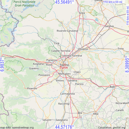
Turin GPS coordinates[2]
45° 4' 13.764" North, 7° 41' 12.552" East
| Map corner | latitude | longitude |
|---|---|---|
| Upper-left | 45.56491°, | 6.9837° |
| Center: | 45.07049°, | 7.68682° |
| Lower-right: | 44.57176°, | 8.38995° |
| Map W x H: | 110.4×110.4 km | = 68.6×68.6mi |
| max Lat: | 47.04031° ⇑38.3% North |
| Turin: | 45.07049° |
| min Lat: | ⇓61.7% South 35.50142° |
| min Long | Turin | max Long |
| 6.69888° | 7.68682° | 18.48682° |
| W 3.6%⇐ | ⇒96.4% E |
Elevation
Elevation of Turin is 245 m = 804 ft, and this is 61.7 m = 202 ft below average elevation for this country.
| Max E: |
2085 m = 6841 ft | 48.3% |
| Avg. | 306.7 m = 1006 ft | |
| Turin | 245 m = 804 ft | |
Min E: |
-4 m = -13 ft | 51.7% |
See also: Turin elevation on elevation.city.
Geographical zone
Turin is located in North temperate zone (between Tropic of Cancer and the Arctic Circle). Distance of this North polar circle is 2389.8 km =1485 mi to North.| Distance of | km | miles | from Turin |
|---|---|---|---|
| North Pole | 4995.7 | 3104.2 | to North |
| Arctic Circle | 2389.8 | 1485 | to North |
| Tropic Cancer | 2405.4 | 1494.6 | to South |
| Equator | 5011.4 | 3113.9 | to South |


Nearby cities:
15 places around Turin: (largest is in red/bold)
• Borgaro Torinese
9.3 km =5.8 mi,  344°
344°
• Fornaci
8.4 km =5.2 mi,  235°
235°
• Gerbido
6.4 km =4 mi, 243°
• Grugliasco
8.4 km =5.2 mi,  265°
265°
• Lesna
5.5 km =3.4 mi,  250°
250°
• Mappano
8.8 km =5.5 mi,  10°
10°
• Moncalieri
7.9 km =4.9 mi,  182°
182°
• Nichelino
8.2 km =5.1 mi,  198°
198°
• Olimpia
7 km =4.3 mi,  29°
29°
• Pecetto
7.8 km =4.8 mi,  139°
139°
• Pino Torinese
7.9 km =4.9 mi,  115°
115°
• Revigliasco
7.1 km =4.4 mi,  149°
149°
• San Mauro Torinese
7.4 km =4.6 mi,  60°
60°
• Savonera
7.4 km =4.6 mi,  310°
310°
• Venaria Reale
7.5 km =4.7 mi,  324°
324°
Sources, notices
• [Note1] Compared only with cities in Italy existing in our database
• [Src1] Map data: © OpenStreetMap contributors (CC-BY-SA)
• [Src2] Other city data from geonames.org with taken over terms of usage.
• [Src3] Geographical zone / Annual Mean Temperature by Robert A. Rohde @ Wikipedia
