Grugliasco geodata
Grugliasco (Piedmont) is a seat of a third-order administrative division; located in Italy in Europe/Rome (GMT+2) time zone. With population of 33,100 people, there are 236 cities with bigger population in this country. Compared to other cities in Italy, 61.6% of cities are located further ↓South; 97.2% of cities are located further →East and 59.6% of cities have lower elevation than Grugliasco. Note1


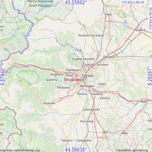
Grugliasco GPS coordinates[2]
45° 3' 54.576" North, 7° 34' 46.344" East
| Map corner | latitude | longitude |
|---|---|---|
| Upper-left | 45.55962°, | 6.87642° |
| Center: | 45.06516°, | 7.57954° |
| Lower-right: | 44.56638°, | 8.28267° |
| Map W x H: | 110.4×110.4 km | = 68.6×68.6mi |
| max Lat: | 47.04031° ⇑38.4% North |
| Grugliasco: | 45.06516° |
| min Lat: | ⇓61.6% South 35.50142° |
| min Long | Grugliasco | max Long |
| 6.69888° | 7.57954° | 18.48682° |
| W 2.8%⇐ | ⇒97.2% E |
Elevation
Elevation of Grugliasco is 297 m = 974 ft, and this is 9.7 m = 32 ft below average elevation for this country.
| Max E: |
2085 m = 6841 ft | 40.4% |
| Avg. | 306.7 m = 1006 ft | |
| Grugliasco | 297 m = 974 ft | |
Min E: |
-4 m = -13 ft | 59.6% |
See also: Italy elevation on elevation.city.
Geographical zone
Grugliasco is located in North temperate zone (between Tropic of Cancer and the Arctic Circle). Distance of this North polar circle is 2390.4 km =1485.3 mi to North.| Distance of | km | miles | from Grugliasco |
|---|---|---|---|
| North Pole | 4996.3 | 3104.6 | to North |
| Arctic Circle | 2390.4 | 1485.3 | to North |
| Tropic Cancer | 2404.9 | 1494.3 | to South |
| Equator | 5010.8 | 3113.6 | to South |


Nearby cities:
15 places around Grugliasco: (largest is in red/bold)
• Alpignano
5.4 km =3.4 mi,  305°
305°
• Beinasco
4.5 km =2.8 mi,  173°
173°
• Borgo Melano
5.5 km =3.4 mi,  182°
182°
• Collegno
1.8 km =1.1 mi,  327°
327°
• Corbiglia
7 km =4.3 mi,  254°
254°
• Fornaci
4.4 km =2.7 mi,  159°
159°
• Gerbido
3.6 km =2.2 mi,  130°
130°
• Lesna
3.4 km =2.1 mi,  110°
110°
• Orbassano
7.4 km =4.6 mi,  206°
206°
• Pasta
6.4 km =4 mi,  199°
199°
• Pianezza
4.9 km =3 mi, 331°
• Rivalta di Torino
5.9 km =3.7 mi,  232°
232°
• Rivoli
5.1 km =3.2 mi,  276°
276°
• Savonera
6.1 km =3.8 mi,  27°
27°
• Tetti Neirotti
3.3 km =2.1 mi, 246°
Sources, notices
• [Note1] Compared only with cities in Italy existing in our database
• [Src1] Map data: © OpenStreetMap contributors (CC-BY-SA)
• [Src2] Other city data from geonames.org with taken over terms of usage.
• [Src3] Geographical zone / Annual Mean Temperature by Robert A. Rohde @ Wikipedia
