Torella dei Lombardi geodata
Torella dei Lombardi (Campania) is a seat of a third-order administrative division; located in Italy in Europe/Rome (GMT+2) time zone. With population of 852 people, there are 7395 cities with bigger population in this country. Compared to other cities in Italy, 79.3% of cities are located further ↑North; 88% of cities are located further ←West and 89.2% of cities have lower elevation than Torella dei Lombardi. Note1
Administrative division(s):
- Level 1: Campania
- Level 2: Provincia di Avellino
- Level 3: Torella dei Lombardi
Current local time in Torella dei Lombardi:
09:34 PM, WednesdayDifference from your time zone: hours


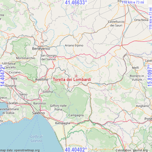
Torella dei Lombardi GPS coordinates[2]
40° 56' 14.316" North, 15° 6' 28.224" East
| Map corner | latitude | longitude |
|---|---|---|
| Upper-left | 41.46633°, | 14.40472° |
| Center: | 40.93731°, | 15.10784° |
| Lower-right: | 40.40402°, | 15.81097° |
| Map W x H: | 118.1×118.1 km | = 73.4×73.4mi |
| max Lat: | 47.04031° ⇑79.3% North |
| Torella dei Lombardi: | 40.93731° |
| min Lat: | ⇓20.7% South 35.50142° |
| min Long | Torella dei Lom | max Long |
| 6.69888° | 15.10784° | 18.48682° |
| W 88%⇐ | ⇒12% E |
Elevation
Elevation of Torella dei Lombardi is 700 m = 2297 ft, and this is 393.3 m = 1290 ft above average elevation for this country.
| Max E: |
2085 m = 6841 ft | 10.8% |
| Torella dei Lombardi | 700 m 2297 ft | |
| Avg. | 306.7 m = 1006 ft | |
Min E: |
-4 m = -13 ft | 89.2% |
See also: Italy elevation on elevation.city.
Geographical zone
Torella dei Lombardi is located in North temperate zone (between Tropic of Cancer and the Arctic Circle). Distance of this Northern Tropic circle is 1945.9 km =1209.1 mi to South.| Distance of | km | miles | from Torella dei Lombardi |
|---|---|---|---|
| North Pole | 5455.3 | 3389.8 | to North |
| Arctic Circle | 2849.4 | 1770.5 | to North |
| Tropic Cancer | 1945.9 | 1209.1 | to South |
| Equator | 4551.8 | 2828.4 | to South |


Nearby cities:
15 places around Torella dei Lombardi: (largest is in red/bold)
• Cassano Irpino
10.1 km =6.3 mi,  222°
222°
• Castelfranci
5.5 km =3.4 mi,  262°
262°
• Castelvetere sul Calore
10.2 km =6.3 mi,  265°
265°
• Frigento
8.2 km =5.1 mi,  355°
355°
• Gesualdo
8.1 km =5 mi,  338°
338°
• Guardia Lombardi
8.6 km =5.3 mi,  79°
79°
• Lioni
8.9 km =5.5 mi,  134°
134°
• Montemarano
9.6 km =6 mi,  254°
254°
• Nusco
5.6 km =3.5 mi,  193°
193°
• Pagliara
6.8 km =4.2 mi,  12°
12°
• Paternopoli
7.5 km =4.7 mi,  301°
301°
• Rocca San Felice
5.1 km =3.2 mi,  73°
73°
• Sant'Angelo dei Lombardi
5.7 km =3.5 mi,  98°
98°
• Sturno
9.4 km =5.8 mi,  2°
2°
• Villamaina
4.1 km =2.5 mi, 336°
Sources, notices
• [Note1] Compared only with cities in Italy existing in our database
• [Src1] Map data: © OpenStreetMap contributors (CC-BY-SA)
• [Src2] Other city data from geonames.org with taken over terms of usage.
• [Src3] Geographical zone / Annual Mean Temperature by Robert A. Rohde @ Wikipedia
