Gesualdo geodata
Gesualdo (Campania) is a seat of a third-order administrative division; located in Italy in Europe/Rome (GMT+2) time zone. With population of 2,004 people, there are 4147 cities with bigger population in this country. Compared to other cities in Italy, 78.6% of cities are located further ↑North; 87.8% of cities are located further ←West and 88.5% of cities have lower elevation than Gesualdo. Note1


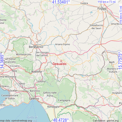
Gesualdo GPS coordinates[2]
41° 0' 19.944" North, 15° 4' 21.432" East
| Map corner | latitude | longitude |
|---|---|---|
| Upper-left | 41.53401°, | 14.3695° |
| Center: | 41.00554°, | 15.07262° |
| Lower-right: | 40.4728°, | 15.77575° |
| Map W x H: | 118×118 km | = 73.3×73.3mi |
| max Lat: | 47.04031° ⇑78.6% North |
| Gesualdo: | 41.00554° |
| min Lat: | ⇓21.4% South 35.50142° |
| min Long | Gesualdo | max Long |
| 6.69888° | 15.07262° | 18.48682° |
| W 87.8%⇐ | ⇒12.2% E |
Elevation
Elevation of Gesualdo is 683 m = 2241 ft, and this is 376.3 m = 1235 ft above average elevation for this country.
| Max E: |
2085 m = 6841 ft | 11.5% |
| Gesualdo | 683 m 2241 ft | |
| Avg. | 306.7 m = 1006 ft | |
Min E: |
-4 m = -13 ft | 88.5% |
See also: Italy elevation on elevation.city.
Geographical zone
Gesualdo is located in North temperate zone (between Tropic of Cancer and the Arctic Circle). Distance of this Northern Tropic circle is 1953.5 km =1213.8 mi to South.| Distance of | km | miles | from Gesualdo |
|---|---|---|---|
| North Pole | 5447.7 | 3385 | to North |
| Arctic Circle | 2841.8 | 1765.8 | to North |
| Tropic Cancer | 1953.5 | 1213.8 | to South |
| Equator | 4559.4 | 2833.1 | to South |


Nearby cities:
15 places around Gesualdo: (largest is in red/bold)
• Castelfranci
8.7 km =5.4 mi,  196°
196°
• Fontanarosa
4.6 km =2.9 mi,  287°
287°
• Frigento
2.4 km =1.5 mi,  75°
75°
• Grottaminarda
7.2 km =4.5 mi,  350°
350°
• Luogosano
7.1 km =4.4 mi,  252°
252°
• Mirabella Eclano
7.5 km =4.7 mi,  305°
305°
• Pagliara
4.6 km =2.9 mi,  102°
102°
• Passo di Mirabella-Pianopantano
7.2 km =4.5 mi,  319°
319°
• Paternopoli
5 km =3.1 mi,  222°
222°
• San Mango sul Calore
9.9 km =6.2 mi,  238°
238°
• Sant'Angelo All'Esca
6.7 km =4.2 mi,  271°
271°
• Sturno
3.8 km =2.4 mi,  61°
61°
• Taurasi
9.5 km =5.9 mi, 273°
• Torella dei Lombardi
8.1 km =5 mi,  158°
158°
• Villamaina
4 km =2.5 mi, 160°
Sources, notices
• [Note1] Compared only with cities in Italy existing in our database
• [Src1] Map data: © OpenStreetMap contributors (CC-BY-SA)
• [Src2] Other city data from geonames.org with taken over terms of usage.
• [Src3] Geographical zone / Annual Mean Temperature by Robert A. Rohde @ Wikipedia
