Frigento geodata
Frigento (Campania) is a seat of a third-order administrative division; located in Italy in Europe/Rome (GMT+2) time zone. With population of 684 people, there are 8395 cities with bigger population in this country. Compared to other cities in Italy, 78.5% of cities are located further ↑North; 88% of cities are located further ←West and 95% of cities have lower elevation than Frigento. Note1


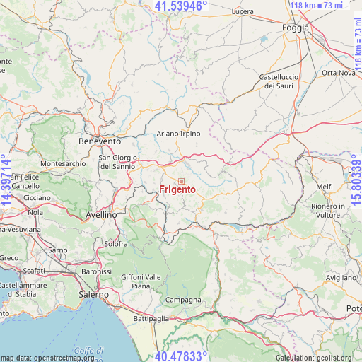
Frigento GPS coordinates[2]
41° 0' 39.708" North, 15° 6' 0.936" East
| Map corner | latitude | longitude |
|---|---|---|
| Upper-left | 41.53946°, | 14.39714° |
| Center: | 41.01103°, | 15.10026° |
| Lower-right: | 40.47833°, | 15.80339° |
| Map W x H: | 118×118 km | = 73.3×73.3mi |
| max Lat: | 47.04031° ⇑78.5% North |
| Frigento: | 41.01103° |
| min Lat: | ⇓21.5% South 35.50142° |
| min Long | Frigento | max Long |
| 6.69888° | 15.10026° | 18.48682° |
| W 88%⇐ | ⇒12% E |
Elevation
Elevation of Frigento is 875 m = 2871 ft, and this is 568.3 m = 1865 ft above average elevation for this country.
| Max E: |
2085 m = 6841 ft | 5% |
| Frigento | 875 m 2871 ft | |
| Avg. | 306.7 m = 1006 ft | |
Min E: |
-4 m = -13 ft | 95% |
See also: Italy elevation on elevation.city.
Geographical zone
Frigento is located in North temperate zone (between Tropic of Cancer and the Arctic Circle). Distance of this Northern Tropic circle is 1954.1 km =1214.2 mi to South.| Distance of | km | miles | from Frigento |
|---|---|---|---|
| North Pole | 5447.1 | 3384.7 | to North |
| Arctic Circle | 2841.2 | 1765.4 | to North |
| Tropic Cancer | 1954.1 | 1214.2 | to South |
| Equator | 4560 | 2833.5 | to South |


Nearby cities:
15 places around Frigento: (largest is in red/bold)
• Carife
9.4 km =5.8 mi,  79°
79°
• Castel Baronia
8.5 km =5.3 mi,  60°
60°
• Flumeri
8.4 km =5.2 mi,  30°
30°
• Fontanarosa
6.7 km =4.2 mi,  276°
276°
• Gesualdo
2.4 km =1.5 mi,  255°
255°
• Grottaminarda
7.4 km =4.6 mi,  332°
332°
• Mirabella Eclano
9.2 km =5.7 mi,  294°
294°
• Pagliara
2.7 km =1.7 mi,  126°
126°
• Passo di Mirabella-Pianopantano
8.5 km =5.3 mi,  304°
304°
• Paternopoli
7.1 km =4.4 mi,  233°
233°
• Rocca San Felice
8.8 km =5.5 mi,  140°
140°
• Sant'Angelo All'Esca
9 km =5.6 mi,  266°
266°
• Sturno
1.6 km =1 mi,  39°
39°
• Torella dei Lombardi
8.2 km =5.1 mi,  175°
175°
• Villamaina
4.5 km =2.8 mi,  192°
192°
Sources, notices
• [Note1] Compared only with cities in Italy existing in our database
• [Src1] Map data: © OpenStreetMap contributors (CC-BY-SA)
• [Src2] Other city data from geonames.org with taken over terms of usage.
• [Src3] Geographical zone / Annual Mean Temperature by Robert A. Rohde @ Wikipedia
