Tito geodata
Tito (Basilicate) is a seat of a third-order administrative division; located in Italy in Europe/Rome (GMT+2) time zone. With population of 4,237 people, there are 2267 cities with bigger population in this country. Compared to other cities in Italy, 83.6% of cities are located further ↑North; 91.2% of cities are located further ←West and 85.4% of cities have lower elevation than Tito. Note1


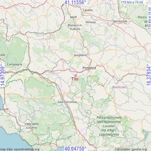
Tito GPS coordinates[2]
40° 35' 1.32" North, 15° 40' 34.356" East
| Map corner | latitude | longitude |
|---|---|---|
| Upper-left | 41.11556°, | 14.97309° |
| Center: | 40.5837°, | 15.67621° |
| Lower-right: | 40.04758°, | 16.37934° |
| Map W x H: | 118.7×118.7 km | = 73.8×73.8mi |
| max Lat: | 47.04031° ⇑83.6% North |
| Tito: | 40.5837° |
| min Lat: | ⇓16.4% South 35.50142° |
| min Long | Tito | max Long |
| 6.69888° | 15.67621° | 18.48682° |
| W 91.2%⇐ | ⇒8.8% E |
Elevation
Elevation of Tito is 621 m = 2037 ft, and this is 314.3 m = 1031 ft above average elevation for this country.
| Max E: |
2085 m = 6841 ft | 14.6% |
| Tito | 621 m 2037 ft | |
| Avg. | 306.7 m = 1006 ft | |
Min E: |
-4 m = -13 ft | 85.4% |
See also: Italy elevation on elevation.city.
Geographical zone
Tito is located in North temperate zone (between Tropic of Cancer and the Arctic Circle). Distance of this Northern Tropic circle is 1906.6 km =1184.7 mi to South.| Distance of | km | miles | from Tito |
|---|---|---|---|
| North Pole | 5494.6 | 3414.2 | to North |
| Arctic Circle | 2888.7 | 1795 | to North |
| Tropic Cancer | 1906.6 | 1184.7 | to South |
| Equator | 4512.5 | 2803.9 | to South |


Nearby cities:
15 places around Tito: (largest is in red/bold)
• Abriola
14.3 km =8.9 mi,  126°
126°
• Baragiano
12.8 km =8 mi,  327°
327°
• Brienza
12.5 km =7.8 mi,  198°
198°
• Madonna del Pantano
8.1 km =5 mi,  103°
103°
• Picerno
6.9 km =4.3 mi,  335°
335°
• Pignola
9.1 km =5.7 mi, 96°
• Potenza
12.9 km =8 mi,  59°
59°
• Ruoti
14.8 km =9.2 mi,  2°
2°
• Sant'Angelo le Fratte
10.6 km =6.6 mi,  245°
245°
• Sasso di Castalda
10.9 km =6.8 mi,  180°
180°
• Satriano di Lucania
5.5 km =3.4 mi,  213°
213°
• Savoia di Lucania
10.7 km =6.6 mi,  261°
261°
• Scalo di Baragiano
15 km =9.3 mi, 325°
• Serra
2.6 km =1.6 mi,  30°
30°
• Vietri di Potenza
14.3 km =8.9 mi,  277°
277°
Sources, notices
• [Note1] Compared only with cities in Italy existing in our database
• [Src1] Map data: © OpenStreetMap contributors (CC-BY-SA)
• [Src2] Other city data from geonames.org with taken over terms of usage.
• [Src3] Geographical zone / Annual Mean Temperature by Robert A. Rohde @ Wikipedia
