Ruoti geodata
Ruoti (Basilicate) is a seat of a third-order administrative division; located in Italy in Europe/Rome (GMT+2) time zone. With population of 1,572 people, there are 4955 cities with bigger population in this country. Compared to other cities in Italy, 82.3% of cities are located further ↑North; 91.2% of cities are located further ←West and 89.4% of cities have lower elevation than Ruoti. Note1


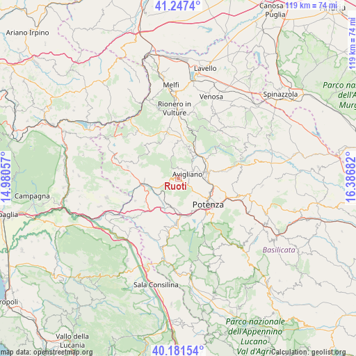
Ruoti GPS coordinates[2]
40° 42' 59.76" North, 15° 41' 1.284" East
| Map corner | latitude | longitude |
|---|---|---|
| Upper-left | 41.2474°, | 14.98057° |
| Center: | 40.7166°, | 15.68369° |
| Lower-right: | 40.18154°, | 16.38682° |
| Map W x H: | 118.5×118.5 km | = 73.6×73.6mi |
| max Lat: | 47.04031° ⇑82.3% North |
| Ruoti: | 40.7166° |
| min Lat: | ⇓17.7% South 35.50142° |
| min Long | Ruoti | max Long |
| 6.69888° | 15.68369° | 18.48682° |
| W 91.2%⇐ | ⇒8.8% E |
Elevation
Elevation of Ruoti is 705 m = 2313 ft, and this is 398.3 m = 1307 ft above average elevation for this country.
| Max E: |
2085 m = 6841 ft | 10.6% |
| Ruoti | 705 m 2313 ft | |
| Avg. | 306.7 m = 1006 ft | |
Min E: |
-4 m = -13 ft | 89.4% |
See also: Italy elevation on elevation.city.
Geographical zone
Ruoti is located in North temperate zone (between Tropic of Cancer and the Arctic Circle). Distance of this Northern Tropic circle is 1921.3 km =1193.8 mi to South.| Distance of | km | miles | from Ruoti |
|---|---|---|---|
| North Pole | 5479.8 | 3405 | to North |
| Arctic Circle | 2873.9 | 1785.8 | to North |
| Tropic Cancer | 1921.3 | 1193.8 | to South |
| Equator | 4527.3 | 2813.1 | to South |


Nearby cities:
15 places around Ruoti: (largest is in red/bold)
• Avigliano
3.6 km =2.2 mi,  59°
59°
• Baragiano
8.6 km =5.3 mi,  241°
241°
• Bella
13 km =8.1 mi,  292°
292°
• Cappelluccia
10.3 km =6.4 mi,  69°
69°
• Filiano
10.7 km =6.6 mi,  11°
11°
• Lagopesole
10.6 km =6.6 mi,  23°
23°
• Picerno
9.2 km =5.7 mi,  202°
202°
• Possidente
10.5 km =6.5 mi,  46°
46°
• Potenza
13.4 km =8.3 mi,  128°
128°
• San Cataldo
3.2 km =2 mi,  331°
331°
• San Giorgio
11.4 km =7.1 mi, 57°
• Scalera
16.1 km =10 mi, 10°
• Scalo di Baragiano
9.5 km =5.9 mi,  255°
255°
• Serra
12.5 km =7.8 mi,  176°
176°
• Tito
14.8 km =9.2 mi, 182°
Sources, notices
• [Note1] Compared only with cities in Italy existing in our database
• [Src1] Map data: © OpenStreetMap contributors (CC-BY-SA)
• [Src2] Other city data from geonames.org with taken over terms of usage.
• [Src3] Geographical zone / Annual Mean Temperature by Robert A. Rohde @ Wikipedia
