Tecchiena geodata
Tecchiena (Latium) is a populated place; located in Italy in Europe/Rome (GMT+2) time zone. With population of 5,044 people, there are 1941 cities with bigger population in this country. Compared to other cities in Italy, 73% of cities are located further ↑North; 71.9% of cities are located further ←West and 53.2% of cities have lower elevation than Tecchiena. Note1


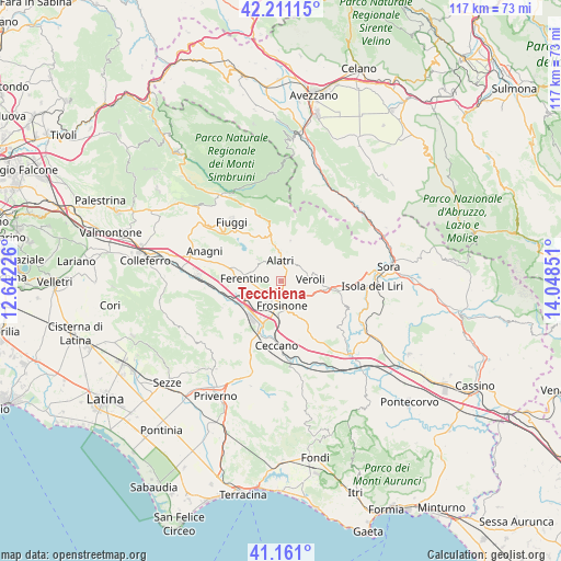
Tecchiena GPS coordinates[2]
41° 41' 17.592" North, 13° 20' 43.368" East
| Map corner | latitude | longitude |
|---|---|---|
| Upper-left | 42.21115°, | 12.64226° |
| Center: | 41.68822°, | 13.34538° |
| Lower-right: | 41.161°, | 14.04851° |
| Map W x H: | 116.8×116.8 km | = 72.6×72.6mi |
| max Lat: | 47.04031° ⇑73% North |
| Tecchiena: | 41.68822° |
| min Lat: | ⇓27% South 35.50142° |
| min Long | Tecchiena | max Long |
| 6.69888° | 13.34538° | 18.48682° |
| W 71.9%⇐ | ⇒28.1% E |
Elevation
Elevation of Tecchiena is 254 m = 833 ft, and this is 52.7 m = 173 ft below average elevation for this country.
| Max E: |
2085 m = 6841 ft | 46.8% |
| Avg. | 306.7 m = 1006 ft | |
| Tecchiena | 254 m = 833 ft | |
Min E: |
-4 m = -13 ft | 53.2% |
See also: Italy elevation on elevation.city.
Geographical zone
Tecchiena is located in North temperate zone (between Tropic of Cancer and the Arctic Circle). Distance of this Northern Tropic circle is 2029.4 km =1261 mi to South.| Distance of | km | miles | from Tecchiena |
|---|---|---|---|
| North Pole | 5371.8 | 3337.9 | to North |
| Arctic Circle | 2765.9 | 1718.7 | to North |
| Tropic Cancer | 2029.4 | 1261 | to South |
| Equator | 4635.3 | 2880.2 | to South |


Nearby cities:
15 places around Tecchiena: (largest is in red/bold)
• Alatri
4.9 km =3 mi,  355°
355°
• Arillette
2.4 km =1.5 mi,  172°
172°
• Basciano
3 km =1.9 mi,  57°
57°
• Case Cibba-Sciascia-Crocifisso-Tondarella-Virano
7.1 km =4.4 mi,  71°
71°
• Castelmassimo
4 km =2.5 mi,  132°
132°
• Ferentino
7.4 km =4.6 mi,  272°
272°
• Fontana Scurano
5.5 km =3.4 mi,  18°
18°
• Frosinone
5.4 km =3.4 mi,  183°
183°
• Intignano
5 km =3.1 mi,  29°
29°
• La Vittoria
6.9 km =4.3 mi,  104°
104°
• Mole Bisleti
2.6 km =1.6 mi,  106°
106°
• Monte San Marino
3.8 km =2.4 mi,  313°
313°
• San Giuseppe le Prata-Cotropagno
4.4 km =2.7 mi, 105°
• Sant'Angelo in Villa-Giglio
7.5 km =4.7 mi, 112°
• Veroli
6 km =3.7 mi,  83°
83°
Sources, notices
• [Note1] Compared only with cities in Italy existing in our database
• [Src1] Map data: © OpenStreetMap contributors (CC-BY-SA)
• [Src2] Other city data from geonames.org with taken over terms of usage.
• [Src3] Geographical zone / Annual Mean Temperature by Robert A. Rohde @ Wikipedia
