Arillette geodata
Arillette (Latium) is a populated place; located in Italy in Europe/Rome (GMT+2) time zone. With population of 937 people, there are 6945 cities with bigger population in this country. Compared to other cities in Italy, 73.3% of cities are located further ↑North; 72% of cities are located further ←West and 52.3% of cities have higher elevation than Arillette. Note1


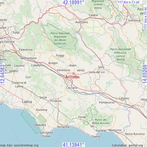
Arillette GPS coordinates[2]
41° 40' 0.48" North, 13° 20' 56.22" East
| Map corner | latitude | longitude |
|---|---|---|
| Upper-left | 42.18991°, | 12.64583° |
| Center: | 41.6668°, | 13.34895° |
| Lower-right: | 41.13941°, | 14.05208° |
| Map W x H: | 116.8×116.8 km | = 72.6×72.6mi |
| max Lat: | 47.04031° ⇑73.3% North |
| Arillette: | 41.6668° |
| min Lat: | ⇓26.7% South 35.50142° |
| min Long | Arillette | max Long |
| 6.69888° | 13.34895° | 18.48682° |
| W 72%⇐ | ⇒28% E |
Elevation
Elevation of Arillette is 220 m = 722 ft, and this is 86.7 m = 284 ft below average elevation for this country.
| Max E: |
2085 m = 6841 ft | 52.3% |
| Avg. | 306.7 m = 1006 ft | |
| Arillette | 220 m = 722 ft | |
Min E: |
-4 m = -13 ft | 47.7% |
See also: Italy elevation on elevation.city.
Geographical zone
Arillette is located in North temperate zone (between Tropic of Cancer and the Arctic Circle). Distance of this Northern Tropic circle is 2027 km =1259.5 mi to South.| Distance of | km | miles | from Arillette |
|---|---|---|---|
| North Pole | 5374.1 | 3339.3 | to North |
| Arctic Circle | 2768.3 | 1720.1 | to North |
| Tropic Cancer | 2027 | 1259.5 | to South |
| Equator | 4632.9 | 2878.7 | to South |


Nearby cities:
15 places around Arillette: (largest is in red/bold)
• Alatri
7.3 km =4.5 mi,  354°
354°
• Basciano
4.6 km =2.9 mi,  28°
28°
• Case Cibba-Sciascia-Crocifisso-Tondarella-Virano
7.9 km =4.9 mi,  54°
54°
• Castelmassimo
2.7 km =1.7 mi,  97°
97°
• Fontana Scurano
7.7 km =4.8 mi,  10°
10°
• Frosinone
3.1 km =1.9 mi,  192°
192°
• Intignano
7.1 km =4.4 mi,  17°
17°
• La Vittoria
6.4 km =4 mi,  84°
84°
• Mole Bisleti
2.8 km =1.7 mi, 54°
• Monte San Marino
5.9 km =3.7 mi,  328°
328°
• San Giuseppe le Prata-Cotropagno
4.1 km =2.5 mi,  72°
72°
• Sant'Angelo in Villa-Giglio
6.6 km =4.1 mi,  94°
94°
• Tecchiena
2.4 km =1.5 mi, 352°
• Torrice
5.9 km =3.7 mi,  128°
128°
• Veroli
6.4 km =4 mi,  61°
61°
Sources, notices
• [Note1] Compared only with cities in Italy existing in our database
• [Src1] Map data: © OpenStreetMap contributors (CC-BY-SA)
• [Src2] Other city data from geonames.org with taken over terms of usage.
• [Src3] Geographical zone / Annual Mean Temperature by Robert A. Rohde @ Wikipedia
