San Giuseppe le Prata-Cotropagno geodata
San Giuseppe le Prata-Cotropagno (Latium) is a populated place; located in Italy in Europe/Rome (GMT+2) time zone. With population of 1,655 people, there are 4770 cities with bigger population in this country. Compared to other cities in Italy, 73.1% of cities are located further ↑North; 72.3% of cities are located further ←West and 50.7% of cities have lower elevation than San Giuseppe le Prata-Cotropagno. Note1
Current local time in San Giuseppe le Prata-Cotropagno:
09:02 PM, WednesdayDifference from your time zone: hours


San Giuseppe le Prata-Cotropagno GPS coordinates[2]
41° 40' 40.368" North, 13° 23' 47.904" East
| Map corner | latitude | longitude |
|---|---|---|
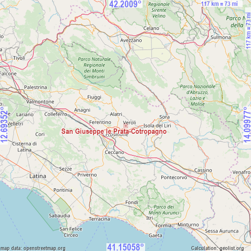
| Upper-left | 42.2009°, | 12.69352° |
| Center: | 41.67788°, | 13.39664° |
| Lower-right: | 41.15058°, | 14.09977° |
| Map W x H: | 116.8×116.8 km | = 72.6×72.6mi |
| max Lat: | 47.04031° ⇑73.1% North |
| San Giuseppe le Prata-Cotropagno: | 41.67788° |
| min Lat: | ⇓26.9% South 35.50142° |
| min Long | San Giuseppe le | max Long |
| 6.69888° | 13.39664° | 18.48682° |
| W 72.3%⇐ | ⇒27.7% E |
Elevation
Elevation of San Giuseppe le Prata-Cotropagno is 239 m = 784 ft, and this is 67.7 m = 222 ft below average elevation for this country.
| Max E: |
2085 m = 6841 ft | 49.3% |
| Avg. | 306.7 m = 1006 ft | |
| San Giuseppe le Prata-Cotropagno | 239 m = 784 ft | |
Min E: |
-4 m = -13 ft | 50.7% |
See also: Italy elevation on elevation.city.
Geographical zone
San Giuseppe le Prata-Cotropagno is located in North temperate zone (between Tropic of Cancer and the Arctic Circle). Distance of this Northern Tropic circle is 2028.2 km =1260.3 mi to South.| Distance of | km | miles | from San Giuseppe le Prata-Cotropagno |
|---|---|---|---|
| North Pole | 5372.9 | 3338.6 | to North |
| Arctic Circle | 2767 | 1719.3 | to North |
| Tropic Cancer | 2028.2 | 1260.3 | to South |
| Equator | 4634.1 | 2879.5 | to South |


Nearby cities:
15 places around San Giuseppe le Prata-Cotropagno: (largest is in red/bold)
• Arillette
4.1 km =2.5 mi,  252°
252°
• Basciano
3.3 km =2.1 mi,  327°
327°
• Casavitola
4.8 km =3 mi,  127°
127°
• Case Campoli-Panetta
6.3 km =3.9 mi,  95°
95°
• Case Cibba-Sciascia-Crocifisso-Tondarella-Virano
4.2 km =2.6 mi,  36°
36°
• Castelmassimo
2 km =1.2 mi,  220°
220°
• Colleberardi
4.8 km =3 mi,  78°
78°
• Intignano
5.8 km =3.6 mi,  341°
341°
• La Vittoria
2.5 km =1.6 mi, 104°
• Mole Bisleti
1.8 km =1.1 mi,  282°
282°
• Rotabile
5.9 km =3.7 mi,  108°
108°
• Sant'Angelo in Villa-Giglio
3.2 km =2 mi,  123°
123°
• Tecchiena
4.4 km =2.7 mi,  285°
285°
• Torrice
4.9 km =3 mi,  173°
173°
• Veroli
2.5 km =1.6 mi, 42°
Sources, notices
• [Note1] Compared only with cities in Italy existing in our database
• [Src1] Map data: © OpenStreetMap contributors (CC-BY-SA)
• [Src2] Other city data from geonames.org with taken over terms of usage.
• [Src3] Geographical zone / Annual Mean Temperature by Robert A. Rohde @ Wikipedia
