Le Casine-Perignano-Spinelli geodata
Le Casine-Perignano-Spinelli (Tuscany) is a populated place; located in Italy in Europe/Rome (GMT+2) time zone. With population of 3,263 people, there are 2862 cities with bigger population in this country. Compared to other cities in Italy, 59% of cities are located further ↑North; 62% of cities are located further →East and 87.8% of cities have higher elevation than Le Casine-Perignano-Spinelli. Note1
Current local time in Le Casine-Perignano-Spinelli:
08:04 PM, WednesdayDifference from your time zone: hours


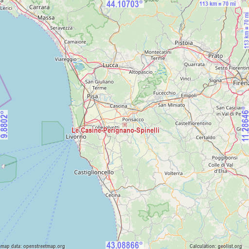
Le Casine-Perignano-Spinelli GPS coordinates[2]
43° 36' 0" North, 10° 34' 59.988" East
| Map corner | latitude | longitude |
|---|---|---|
| Upper-left | 44.10703°, | 9.8802° |
| Center: | 43.6°, | 10.58333° |
| Lower-right: | 43.08866°, | 11.28646° |
| Map W x H: | 113.2×113.2 km | = 70.3×70.3mi |
| max Lat: | 47.04031° ⇑59% North |
| Le Casine-Perignano-Spinelli: | 43.6° |
| min Lat: | ⇓41% South 35.50142° |
| min Long | Le Casine-Perig | max Long |
| 6.69888° | 10.58333° | 18.48682° |
| W 38%⇐ | ⇒62% E |
Elevation
Elevation of Le Casine-Perignano-Spinelli is 23 m = 75 ft, and this is 283.7 m = 931 ft below average elevation for this country.
| Max E: |
2085 m = 6841 ft | 87.8% |
| Avg. | 306.7 m = 1006 ft | |
| Le Casine-Perignano-Spinelli | 23 m = 75 ft | |
Min E: |
-4 m = -13 ft | 12.2% |
See also: Italy elevation on elevation.city.
Geographical zone
Le Casine-Perignano-Spinelli is located in North temperate zone (between Tropic of Cancer and the Arctic Circle). Distance of this Northern Tropic circle is 2241.9 km =1393.1 mi to South.| Distance of | km | miles | from Le Casine-Perignano-Spinelli |
|---|---|---|---|
| North Pole | 5159.2 | 3205.8 | to North |
| Arctic Circle | 2553.3 | 1586.5 | to North |
| Tropic Cancer | 2241.9 | 1393.1 | to South |
| Equator | 4847.9 | 3012.3 | to South |


Nearby cities:
15 places around Le Casine-Perignano-Spinelli: (largest is in red/bold)
• Capannoli
7.4 km =4.6 mi,  99°
99°
• Cenaia
3.9 km =2.4 mi,  280°
280°
• Crespina
3.4 km =2.1 mi,  207°
207°
• Fauglia
6.5 km =4 mi,  240°
240°
• Il Romito
7.4 km =4.6 mi,  42°
42°
• La Borra
6 km =3.7 mi, 37°
• Lari
3.8 km =2.4 mi,  169°
169°
• Latignano
6.4 km =4 mi,  342°
342°
• Lavaiano
3.3 km =2.1 mi,  1°
1°
• Ponsacco
4.3 km =2.7 mi,  53°
53°
• Quattro Strade
1.2 km =0.7 mi,  298°
298°
• San Pietro Belvedere
7.4 km =4.6 mi,  116°
116°
• Santa Lucia
5.4 km =3.4 mi,  24°
24°
• Treggiaia
7.7 km =4.8 mi,  70°
70°
• Val di Cava
6.8 km =4.2 mi, 51°
Sources, notices
• [Note1] Compared only with cities in Italy existing in our database
• [Src1] Map data: © OpenStreetMap contributors (CC-BY-SA)
• [Src2] Other city data from geonames.org with taken over terms of usage.
• [Src3] Geographical zone / Annual Mean Temperature by Robert A. Rohde @ Wikipedia
