Terlizzi geodata
Terlizzi (Apulia) is a seat of a third-order administrative division; located in Italy in Europe/Rome (GMT+2) time zone. With population of 25,811 people, there are 318 cities with bigger population in this country. Compared to other cities in Italy, 77.3% of cities are located further ↑North; 96.7% of cities are located further ←West and 55.9% of cities have higher elevation than Terlizzi. Note1


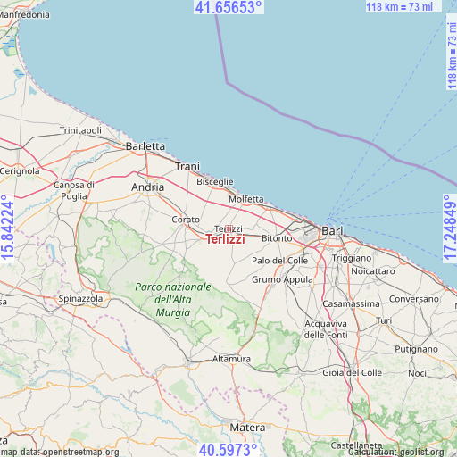
Terlizzi GPS coordinates[2]
41° 7' 44.58" North, 16° 32' 43.296" East
| Map corner | latitude | longitude |
|---|---|---|
| Upper-left | 41.65653°, | 15.84224° |
| Center: | 41.12905°, | 16.54536° |
| Lower-right: | 40.5973°, | 17.24849° |
| Map W x H: | 117.8×117.8 km | = 73.2×73.2mi |
| max Lat: | 47.04031° ⇑77.3% North |
| Terlizzi: | 41.12905° |
| min Lat: | ⇓22.7% South 35.50142° |
| min Long | Terlizzi | max Long |
| 6.69888° | 16.54536° | 18.48682° |
| W 96.7%⇐ | ⇒3.3% E |
Elevation
Elevation of Terlizzi is 196 m = 643 ft, and this is 110.7 m = 363 ft below average elevation for this country.
| Max E: |
2085 m = 6841 ft | 55.9% |
| Avg. | 306.7 m = 1006 ft | |
| Terlizzi | 196 m = 643 ft | |
Min E: |
-4 m = -13 ft | 44.1% |
See also: Italy elevation on elevation.city.
Geographical zone
Terlizzi is located in North temperate zone (between Tropic of Cancer and the Arctic Circle). Distance of this Northern Tropic circle is 1967.2 km =1222.4 mi to South.| Distance of | km | miles | from Terlizzi |
|---|---|---|---|
| North Pole | 5433.9 | 3376.5 | to North |
| Arctic Circle | 2828.1 | 1757.3 | to North |
| Tropic Cancer | 1967.2 | 1222.4 | to South |
| Equator | 4573.1 | 2841.6 | to South |


Nearby cities:
15 places around Terlizzi: (largest is in red/bold)
• Auricarro
15.1 km =9.4 mi,  129°
129°
• Binetto
18.1 km =11.2 mi, 130°
• Bisceglie
13.2 km =8.2 mi,  343°
343°
• Bitonto
12.4 km =7.7 mi,  99°
99°
• Capirro
17.3 km =10.7 mi,  323°
323°
• Corato
11.5 km =7.1 mi,  282°
282°
• Giovinazzo
12.2 km =7.6 mi,  59°
59°
• Mariotto
8.9 km =5.5 mi,  171°
171°
• Molfetta
9.1 km =5.7 mi,  29°
29°
• Palo del Colle
15.5 km =9.6 mi,  121°
121°
• Palombaio
8.5 km =5.3 mi,  140°
140°
• Quasano
18.1 km =11.2 mi, 172°
• Ruvo di Puglia
5.3 km =3.3 mi,  256°
256°
• Santo Spirito
17.6 km =10.9 mi,  76°
76°
• Toritto
18.4 km =11.4 mi, 142°
Sources, notices
• [Note1] Compared only with cities in Italy existing in our database
• [Src1] Map data: © OpenStreetMap contributors (CC-BY-SA)
• [Src2] Other city data from geonames.org with taken over terms of usage.
• [Src3] Geographical zone / Annual Mean Temperature by Robert A. Rohde @ Wikipedia
