Bisceglie geodata
Bisceglie (Apulia) is a seat of a third-order administrative division; located in Italy in Europe/Rome (GMT+2) time zone. With population of 53,648 people, there are 102 cities with bigger population in this country. Compared to other cities in Italy, 76.6% of cities are located further ↑North; 96.4% of cities are located further ←West and 89% of cities have higher elevation than Bisceglie. Note1
Administrative division(s):
- Level 1: Apulia
- Level 2: Provincia di Barletta - Andria - Trani
- Level 3: Bisceglie


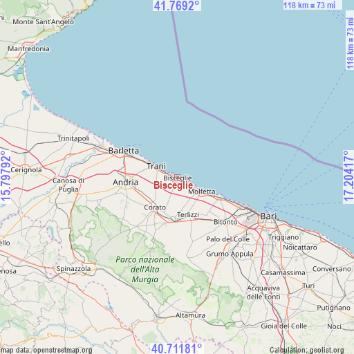
Bisceglie GPS coordinates[2]
41° 14' 33.504" North, 16° 30' 3.744" East
| Map corner | latitude | longitude |
|---|---|---|
| Upper-left | 41.7692°, | 15.79792° |
| Center: | 41.24264°, | 16.50104° |
| Lower-right: | 40.71181°, | 17.20417° |
| Map W x H: | 117.6×117.6 km | = 73.1×73.1mi |
| max Lat: | 47.04031° ⇑76.6% North |
| Bisceglie: | 41.24264° |
| min Lat: | ⇓23.4% South 35.50142° |
| min Long | Bisceglie | max Long |
| 6.69888° | 16.50104° | 18.48682° |
| W 96.4%⇐ | ⇒3.6% E |
Elevation
Elevation of Bisceglie is 20 m = 66 ft, and this is 286.7 m = 941 ft below average elevation for this country.
| Max E: |
2085 m = 6841 ft | 89% |
| Avg. | 306.7 m = 1006 ft | |
| Bisceglie | 20 m = 66 ft | |
Min E: |
-4 m = -13 ft | 11% |
See also: Bisceglie elevation on elevation.city.
Geographical zone
Bisceglie is located in North temperate zone (between Tropic of Cancer and the Arctic Circle). Distance of this Northern Tropic circle is 1979.8 km =1230.2 mi to South.| Distance of | km | miles | from Bisceglie |
|---|---|---|---|
| North Pole | 5421.3 | 3368.6 | to North |
| Arctic Circle | 2815.4 | 1749.4 | to North |
| Tropic Cancer | 1979.8 | 1230.2 | to South |
| Equator | 4585.8 | 2849.5 | to South |


Nearby cities:
15 places around Bisceglie: (largest is in red/bold)
• Andria
17 km =10.6 mi,  265°
265°
• Auricarro
27 km =16.8 mi,  145°
145°
• Barletta
20 km =12.4 mi,  293°
293°
• Bitonto
21.7 km =13.5 mi,  132°
132°
• Capirro
6.7 km =4.2 mi,  280°
280°
• Corato
12.6 km =7.8 mi,  216°
216°
• Giovinazzo
15.6 km =9.7 mi,  114°
114°
• Mariotto
22 km =13.7 mi,  166°
166°
• Molfetta
9.4 km =5.8 mi,  119°
119°
• Palo del Colle
26.8 km =16.7 mi,  140°
140°
• Palombaio
21.2 km =13.2 mi, 154°
• Ruvo di Puglia
14 km =8.7 mi,  185°
185°
• Santo Spirito
22.5 km =14 mi, 112°
• Terlizzi
13.2 km =8.2 mi,  163°
163°
• Trani
8.5 km =5.3 mi,  296°
296°
Sources, notices
• [Note1] Compared only with cities in Italy existing in our database
• [Src1] Map data: © OpenStreetMap contributors (CC-BY-SA)
• [Src2] Other city data from geonames.org with taken over terms of usage.
• [Src3] Geographical zone / Annual Mean Temperature by Robert A. Rohde @ Wikipedia
