Ruvo di Puglia geodata
Ruvo di Puglia (Apulia) is a seat of a third-order administrative division; located in Italy in Europe/Rome (GMT+2) time zone. With population of 23,938 people, there are 342 cities with bigger population in this country. Compared to other cities in Italy, 77.4% of cities are located further ↑North; 96.3% of cities are located further ←West and 53.9% of cities have lower elevation than Ruvo di Puglia. Note1


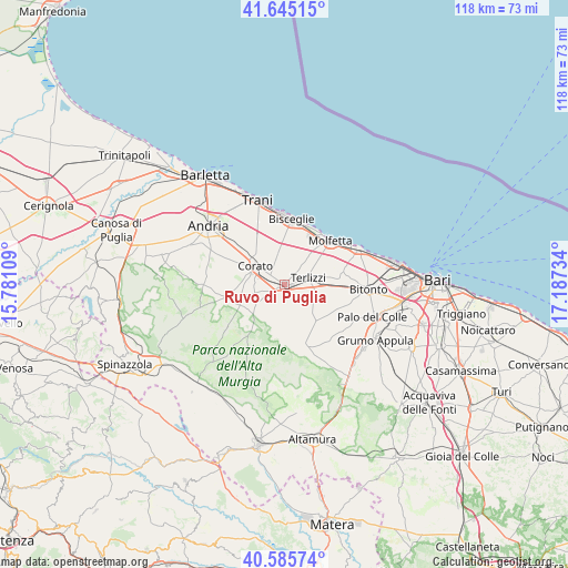
Ruvo di Puglia GPS coordinates[2]
41° 7' 3.288" North, 16° 29' 3.156" East
| Map corner | latitude | longitude |
|---|---|---|
| Upper-left | 41.64515°, | 15.78109° |
| Center: | 41.11758°, | 16.48421° |
| Lower-right: | 40.58574°, | 17.18734° |
| Map W x H: | 117.8×117.8 km | = 73.2×73.2mi |
| max Lat: | 47.04031° ⇑77.4% North |
| Ruvo di Puglia: | 41.11758° |
| min Lat: | ⇓22.6% South 35.50142° |
| min Long | Ruvo di Puglia | max Long |
| 6.69888° | 16.48421° | 18.48682° |
| W 96.3%⇐ | ⇒3.7% E |
Elevation
Elevation of Ruvo di Puglia is 259 m = 850 ft, and this is 47.7 m = 156 ft below average elevation for this country.
| Max E: |
2085 m = 6841 ft | 46.1% |
| Avg. | 306.7 m = 1006 ft | |
| Ruvo di Puglia | 259 m = 850 ft | |
Min E: |
-4 m = -13 ft | 53.9% |
See also: Italy elevation on elevation.city.
Geographical zone
Ruvo di Puglia is located in North temperate zone (between Tropic of Cancer and the Arctic Circle). Distance of this Northern Tropic circle is 1965.9 km =1221.6 mi to South.| Distance of | km | miles | from Ruvo di Puglia |
|---|---|---|---|
| North Pole | 5435.2 | 3377.3 | to North |
| Arctic Circle | 2829.3 | 1758 | to North |
| Tropic Cancer | 1965.9 | 1221.6 | to South |
| Equator | 4571.8 | 2840.8 | to South |


Nearby cities:
15 places around Ruvo di Puglia: (largest is in red/bold)
• Andria
20.1 km =12.5 mi,  309°
309°
• Auricarro
18.7 km =11.6 mi,  116°
116°
• Bisceglie
14 km =8.7 mi,  5°
5°
• Bitonto
17.3 km =10.7 mi,  92°
92°
• Capirro
16 km =9.9 mi,  341°
341°
• Corato
7.2 km =4.5 mi,  301°
301°
• Giovinazzo
17.3 km =10.7 mi,  64°
64°
• Mariotto
9.9 km =6.2 mi,  139°
139°
• Molfetta
13.3 km =8.3 mi,  46°
46°
• Palo del Colle
19.6 km =12.2 mi,  110°
110°
• Palombaio
11.7 km =7.3 mi, 116°
• Quasano
18.3 km =11.4 mi,  155°
155°
• Terlizzi
5.3 km =3.3 mi,  76°
76°
• Toritto
21.1 km =13.1 mi,  129°
129°
• Trani
18.8 km =11.7 mi, 340°
Sources, notices
• [Note1] Compared only with cities in Italy existing in our database
• [Src1] Map data: © OpenStreetMap contributors (CC-BY-SA)
• [Src2] Other city data from geonames.org with taken over terms of usage.
• [Src3] Geographical zone / Annual Mean Temperature by Robert A. Rohde @ Wikipedia
