Terlano geodata
Terlano (Trentino-Alto Adige) is a seat of a third-order administrative division; located in Italy in Europe/Rome (GMT+2) time zone. With population of 1,823 people, there are 4458 cities with bigger population in this country. Compared to other cities in Italy, 98.5% of cities are located further ↓South; 53.8% of cities are located further →East and 52.8% of cities have lower elevation than Terlano. Note1


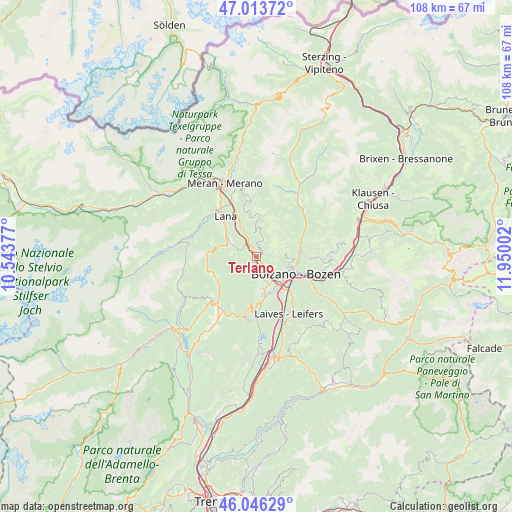
Terlano GPS coordinates[2]
46° 31' 55.776" North, 11° 14' 48.804" East
| Map corner | latitude | longitude |
|---|---|---|
| Upper-left | 47.01372°, | 10.54377° |
| Center: | 46.53216°, | 11.24689° |
| Lower-right: | 46.04629°, | 11.95002° |
| Map W x H: | 107.6×107.6 km | = 66.9×66.9mi |
| max Lat: | 47.04031° ⇑1.5% North |
| Terlano: | 46.53216° |
| min Lat: | ⇓98.5% South 35.50142° |
| min Long | Terlano | max Long |
| 6.69888° | 11.24689° | 18.48682° |
| W 46.2%⇐ | ⇒53.8% E |
Elevation
Elevation of Terlano is 252 m = 827 ft, and this is 54.7 m = 179 ft below average elevation for this country.
| Max E: |
2085 m = 6841 ft | 47.2% |
| Avg. | 306.7 m = 1006 ft | |
| Terlano | 252 m = 827 ft | |
Min E: |
-4 m = -13 ft | 52.8% |
See also: Italy elevation on elevation.city.
Geographical zone
Terlano is located in North temperate zone (between Tropic of Cancer and the Arctic Circle). Distance of this North polar circle is 2227.3 km =1384 mi to North.| Distance of | km | miles | from Terlano |
|---|---|---|---|
| North Pole | 4833.2 | 3003.2 | to North |
| Arctic Circle | 2227.3 | 1384 | to North |
| Tropic Cancer | 2568 | 1595.7 | to South |
| Equator | 5173.9 | 3214.9 | to South |


Nearby cities:
15 places around Terlano: (largest is in red/bold)
• Andriano
2 km =1.2 mi,  216°
216°
• Bolzano
8.5 km =5.3 mi,  122°
122°
• Cornaiano
8.1 km =5 mi,  161°
161°
• Gargazzone
6.8 km =4.2 mi,  329°
329°
• Meltina
6.2 km =3.9 mi,  5°
5°
• Nalles
3.4 km =2.1 mi,  291°
291°
• Postal
9.5 km =5.9 mi, 334°
• San Genesio Atesino
6.3 km =3.9 mi,  87°
87°
• San Michele
8.7 km =5.4 mi,  172°
172°
• San Paolo
6.8 km =4.2 mi, 171°
• Settequerce
2.7 km =1.7 mi,  149°
149°
• Tesimo
7 km =4.3 mi,  301°
301°
• Verano
8.2 km =5.1 mi,  348°
348°
• Verano - Voeran
8.2 km =5.1 mi, 348°
• Vilpiano
3.5 km =2.2 mi, 328°
Sources, notices
• [Note1] Compared only with cities in Italy existing in our database
• [Src1] Map data: © OpenStreetMap contributors (CC-BY-SA)
• [Src2] Other city data from geonames.org with taken over terms of usage.
• [Src3] Geographical zone / Annual Mean Temperature by Robert A. Rohde @ Wikipedia
