San Paolo geodata
San Paolo (Trentino-Alto Adige) is a populated place; located in Italy in Europe/Rome (GMT+2) time zone. With population of 1,472 people, there are 5193 cities with bigger population in this country. Compared to other cities in Italy, 98.2% of cities are located further ↓South; 53.6% of cities are located further →East and 70.6% of cities have lower elevation than San Paolo. Note1
Administrative division(s):
- Level 1: Trentino-Alto Adige
- Level 2: Bolzano
- Level 3: Appiano sulla strada del vino


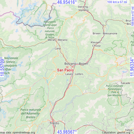
San Paolo GPS coordinates[2]
46° 28' 19.452" North, 11° 15' 36.756" East
| Map corner | latitude | longitude |
|---|---|---|
| Upper-left | 46.95416°, | 10.55709° |
| Center: | 46.47207°, | 11.26021° |
| Lower-right: | 45.98567°, | 11.96334° |
| Map W x H: | 107.7×107.7 km | = 66.9×66.9mi |
| max Lat: | 47.04031° ⇑1.8% North |
| San Paolo: | 46.47207° |
| min Lat: | ⇓98.2% South 35.50142° |
| min Long | San Paolo | max Long |
| 6.69888° | 11.26021° | 18.48682° |
| W 46.4%⇐ | ⇒53.6% E |
Elevation
Elevation of San Paolo is 400 m = 1312 ft, and this is 93.3 m = 306 ft above average elevation for this country.
| Max E: |
2085 m = 6841 ft | 29.4% |
| San Paolo | 400 m 1312 ft | |
| Avg. | 306.7 m = 1006 ft | |
Min E: |
-4 m = -13 ft | 70.6% |
See also: Italy elevation on elevation.city.
Geographical zone
San Paolo is located in North temperate zone (between Tropic of Cancer and the Arctic Circle). Distance of this North polar circle is 2234 km =1388.1 mi to North.| Distance of | km | miles | from San Paolo |
|---|---|---|---|
| North Pole | 4839.9 | 3007.4 | to North |
| Arctic Circle | 2234 | 1388.1 | to North |
| Tropic Cancer | 2561.3 | 1591.5 | to South |
| Equator | 5167.2 | 3210.7 | to South |


Nearby cities:
15 places around San Paolo: (largest is in red/bold)
• Andriano
5.5 km =3.4 mi,  336°
336°
• Bolzano
6.4 km =4 mi,  71°
71°
• Bronzolo
8.9 km =5.5 mi,  148°
148°
• Caldaro sulla Strada del Vino
6.6 km =4.1 mi,  189°
189°
• Cornaiano
1.9 km =1.2 mi,  121°
121°
• Laives
7.8 km =4.8 mi,  130°
130°
• Nalles
8.9 km =5.5 mi,  332°
332°
• Pineta
7.6 km =4.7 mi, 118°
• Ruffrè
9 km =5.6 mi,  224°
224°
• San Genesio Atesino
8.8 km =5.5 mi,  37°
37°
• San Giacomo
5.9 km =3.7 mi,  107°
107°
• San Michele
1.9 km =1.2 mi,  176°
176°
• Settequerce
4.4 km =2.7 mi,  4°
4°
• Terlano
6.8 km =4.2 mi,  351°
351°
• Vadena
7.3 km =4.5 mi, 152°
Sources, notices
• [Note1] Compared only with cities in Italy existing in our database
• [Src1] Map data: © OpenStreetMap contributors (CC-BY-SA)
• [Src2] Other city data from geonames.org with taken over terms of usage.
• [Src3] Geographical zone / Annual Mean Temperature by Robert A. Rohde @ Wikipedia
