Andriano geodata
Andriano (Trentino-Alto Adige) is a seat of a third-order administrative division; located in Italy in Europe/Rome (GMT+2) time zone. With population of 916 people, there are 7056 cities with bigger population in this country. Compared to other cities in Italy, 98.5% of cities are located further ↓South; 54% of cities are located further →East and 58.9% of cities have lower elevation than Andriano. Note1


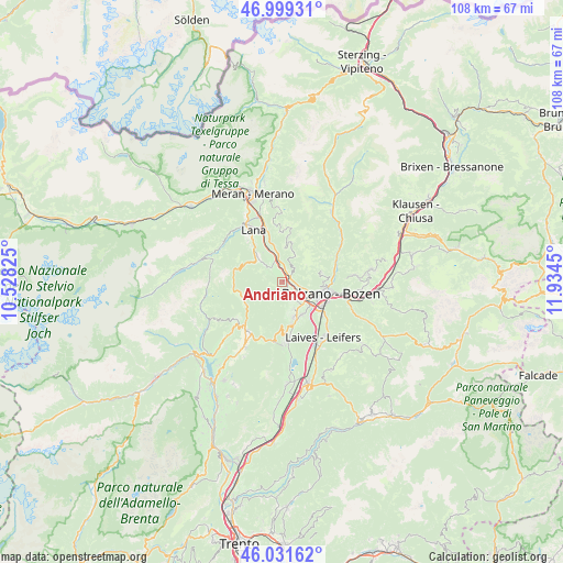
Andriano GPS coordinates[2]
46° 31' 3.432" North, 11° 13' 52.932" East
| Map corner | latitude | longitude |
|---|---|---|
| Upper-left | 46.99931°, | 10.52825° |
| Center: | 46.51762°, | 11.23137° |
| Lower-right: | 46.03162°, | 11.9345° |
| Map W x H: | 107.6×107.6 km | = 66.9×66.9mi |
| max Lat: | 47.04031° ⇑1.5% North |
| Andriano: | 46.51762° |
| min Lat: | ⇓98.5% South 35.50142° |
| min Long | Andriano | max Long |
| 6.69888° | 11.23137° | 18.48682° |
| W 46%⇐ | ⇒54% E |
Elevation
Elevation of Andriano is 291 m = 955 ft, and this is 15.7 m = 52 ft below average elevation for this country.
| Max E: |
2085 m = 6841 ft | 41.1% |
| Avg. | 306.7 m = 1006 ft | |
| Andriano | 291 m = 955 ft | |
Min E: |
-4 m = -13 ft | 58.9% |
See also: Italy elevation on elevation.city.
Geographical zone
Andriano is located in North temperate zone (between Tropic of Cancer and the Arctic Circle). Distance of this North polar circle is 2228.9 km =1385 mi to North.| Distance of | km | miles | from Andriano |
|---|---|---|---|
| North Pole | 4834.8 | 3004.2 | to North |
| Arctic Circle | 2228.9 | 1385 | to North |
| Tropic Cancer | 2566.4 | 1594.7 | to South |
| Equator | 5172.3 | 3213.9 | to South |


Nearby cities:
15 places around Andriano: (largest is in red/bold)
• Bolzano
8.8 km =5.5 mi,  109°
109°
• Cornaiano
7.1 km =4.4 mi,  147°
147°
• Gargazzone
7.8 km =4.8 mi,  342°
342°
• Meltina
8 km =5 mi,  13°
13°
• Nalles
3.5 km =2.2 mi,  326°
326°
• San Felice
8.2 km =5.1 mi,  251°
251°
• San Genesio Atesino
7.8 km =4.8 mi,  75°
75°
• San Michele
7.4 km =4.6 mi,  161°
161°
• San Paolo
5.5 km =3.4 mi, 156°
• Senale
9.3 km =5.8 mi,  265°
265°
• Settequerce
2.7 km =1.7 mi, 105°
• Terlano
2 km =1.2 mi,  36°
36°
• Tesimo
7.1 km =4.4 mi,  318°
318°
• Verano - Voeran
9.7 km =6 mi,  357°
357°
• Vilpiano
4.6 km =2.9 mi,  352°
352°
Sources, notices
• [Note1] Compared only with cities in Italy existing in our database
• [Src1] Map data: © OpenStreetMap contributors (CC-BY-SA)
• [Src2] Other city data from geonames.org with taken over terms of usage.
• [Src3] Geographical zone / Annual Mean Temperature by Robert A. Rohde @ Wikipedia
