Teggiano-Macchiaroli geodata
Teggiano-Macchiaroli (Campania) is a seat of a third-order administrative division; located in Italy in Europe/Rome (GMT+1) time zone. With population of 2,103 people, there are 3981 cities with bigger population in this country. Compared to other cities in Italy, 85% of cities are located further ↑North; 90.7% of cities are located further ←West and 86.3% of cities have lower elevation than Teggiano-Macchiaroli. Note1


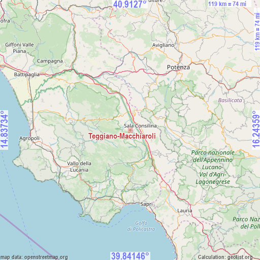
Teggiano-Macchiaroli GPS coordinates[2]
40° 22' 45.156" North, 15° 32' 25.656" East
| Map corner | latitude | longitude |
|---|---|---|
| Upper-left | 40.9127°, | 14.83734° |
| Center: | 40.37921°, | 15.54046° |
| Lower-right: | 39.84146°, | 16.24359° |
| Map W x H: | 119.1×119.1 km | = 74×74mi |
| max Lat: | 47.04031° ⇑85% North |
| Teggiano-Macchiaroli: | 40.37921° |
| min Lat: | ⇓15% South 35.50142° |
| min Long | Teggiano-Macchi | max Long |
| 6.69888° | 15.54046° | 18.48682° |
| W 90.7%⇐ | ⇒9.3% E |
Elevation
Elevation of Teggiano-Macchiaroli is 638 m = 2093 ft, and this is 331.3 m = 1087 ft above average elevation for this country.
| Max E: |
2085 m = 6841 ft | 13.7% |
| Teggiano-Macchiaroli | 638 m 2093 ft | |
| Avg. | 306.7 m = 1006 ft | |
Min E: |
-4 m = -13 ft | 86.3% |
See also: Italy elevation on elevation.city.
Geographical zone
Teggiano-Macchiaroli is located in North temperate zone (between Tropic of Cancer and the Arctic Circle). Distance of this Northern Tropic circle is 1883.8 km =1170.5 mi to South.| Distance of | km | miles | from Teggiano-Macchiaroli |
|---|---|---|---|
| North Pole | 5517.3 | 3428.3 | to North |
| Arctic Circle | 2911.4 | 1809.1 | to North |
| Tropic Cancer | 1883.8 | 1170.5 | to South |
| Equator | 4489.7 | 2789.8 | to South |


Nearby cities:
15 places around Teggiano-Macchiaroli: (largest is in red/bold)
• Atena Lucana
8.5 km =5.3 mi,  9°
9°
• Brienza
13.3 km =8.3 mi,  34°
34°
• Buonabitacolo
14.1 km =8.8 mi,  150°
150°
• Fontana Vaglio
6 km =3.7 mi,  312°
312°
• Monte San Giacomo
3.9 km =2.4 mi,  177°
177°
• Padula
10.8 km =6.7 mi,  114°
114°
• Prato Perillo
2.4 km =1.5 mi,  326°
326°
• Sacco
13.8 km =8.6 mi,  268°
268°
• Sala Consilina
5 km =3.1 mi,  60°
60°
• San Pietro al Tanagro
9.6 km =6 mi, 331°
• San Rufo
8.9 km =5.5 mi, 313°
• Sant'Arsenio
11.3 km =7 mi, 334°
• Sassano
4.8 km =3 mi, 153°
• Silla
4.4 km =2.7 mi,  117°
117°
• Varco Notar Ercole
6 km =3.7 mi,  127°
127°
Sources, notices
• [Note1] Compared only with cities in Italy existing in our database
• [Src1] Map data: © OpenStreetMap contributors (CC-BY-SA)
• [Src2] Other city data from geonames.org with taken over terms of usage.
• [Src3] Geographical zone / Annual Mean Temperature by Robert A. Rohde @ Wikipedia
