San Rufo geodata
San Rufo (Campania) is a seat of a third-order administrative division; located in Italy in Europe/Rome (GMT+2) time zone. With population of 670 people, there are 8485 cities with bigger population in this country. Compared to other cities in Italy, 84.5% of cities are located further ↑North; 90.5% of cities are located further ←West and 87.1% of cities have lower elevation than San Rufo. Note1


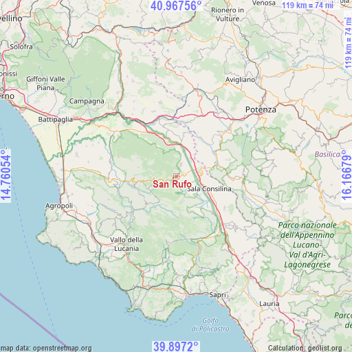
San Rufo GPS coordinates[2]
40° 26' 4.236" North, 15° 27' 49.176" East
| Map corner | latitude | longitude |
|---|---|---|
| Upper-left | 40.96756°, | 14.76054° |
| Center: | 40.43451°, | 15.46366° |
| Lower-right: | 39.8972°, | 16.16679° |
| Map W x H: | 119×119 km | = 73.9×73.9mi |
| max Lat: | 47.04031° ⇑84.5% North |
| San Rufo: | 40.43451° |
| min Lat: | ⇓15.5% South 35.50142° |
| min Long | San Rufo | max Long |
| 6.69888° | 15.46366° | 18.48682° |
| W 90.5%⇐ | ⇒9.5% E |
Elevation
Elevation of San Rufo is 652 m = 2139 ft, and this is 345.3 m = 1133 ft above average elevation for this country.
| Max E: |
2085 m = 6841 ft | 12.9% |
| San Rufo | 652 m 2139 ft | |
| Avg. | 306.7 m = 1006 ft | |
Min E: |
-4 m = -13 ft | 87.1% |
See also: Italy elevation on elevation.city.
Geographical zone
San Rufo is located in North temperate zone (between Tropic of Cancer and the Arctic Circle). Distance of this Northern Tropic circle is 1890 km =1174.4 mi to South.| Distance of | km | miles | from San Rufo |
|---|---|---|---|
| North Pole | 5511.2 | 3424.5 | to North |
| Arctic Circle | 2905.3 | 1805.3 | to North |
| Tropic Cancer | 1890 | 1174.4 | to South |
| Equator | 4495.9 | 2793.6 | to South |


Nearby cities:
15 places around San Rufo: (largest is in red/bold)
• Atena Lucana
8.2 km =5.1 mi,  74°
74°
• Corleto Monforte
7.1 km =4.4 mi,  272°
272°
• Fontana Vaglio
3 km =1.9 mi,  134°
134°
• Monte San Giacomo
12.1 km =7.5 mi,  146°
146°
• Pertosa
12.2 km =7.6 mi,  354°
354°
• Piaggine
12.3 km =7.6 mi,  216°
216°
• Polla
9.3 km =5.8 mi,  17°
17°
• Prato Perillo
6.7 km =4.2 mi, 128°
• Roscigno
10.7 km =6.6 mi,  248°
248°
• Sacco
9.7 km =6 mi,  228°
228°
• Sala Consilina
11.4 km =7.1 mi,  108°
108°
• San Pietro al Tanagro
3 km =1.9 mi,  40°
40°
• Sant'Angelo A Fasanella
10.7 km =6.6 mi,  283°
283°
• Sant'Arsenio
4.4 km =2.7 mi, 22°
• Teggiano-Macchiaroli
8.9 km =5.5 mi, 133°
Sources, notices
• [Note1] Compared only with cities in Italy existing in our database
• [Src1] Map data: © OpenStreetMap contributors (CC-BY-SA)
• [Src2] Other city data from geonames.org with taken over terms of usage.
• [Src3] Geographical zone / Annual Mean Temperature by Robert A. Rohde @ Wikipedia
