Tarquinia geodata
Tarquinia (Latium) is a seat of a third-order administrative division; located in Italy in Europe/Rome (GMT+2) time zone. With population of 11,949 people, there are 779 cities with bigger population in this country. Compared to other cities in Italy, 68.2% of cities are located further ↑North; 52.5% of cities are located further ←West and 64.9% of cities have higher elevation than Tarquinia. Note1


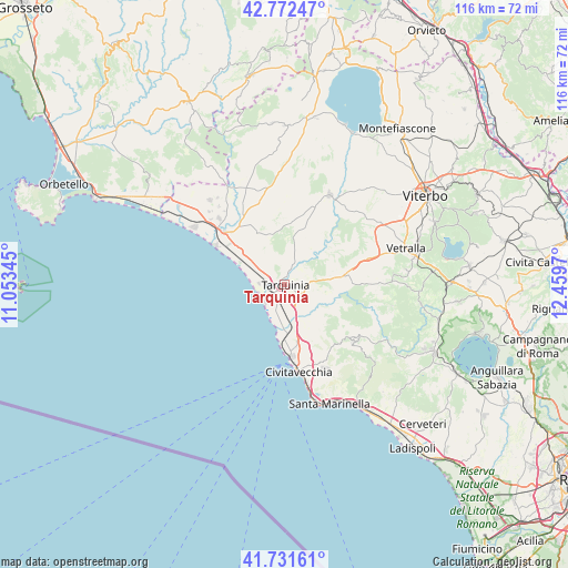
Tarquinia GPS coordinates[2]
42° 15' 15.084" North, 11° 45' 23.652" East
| Map corner | latitude | longitude |
|---|---|---|
| Upper-left | 42.77247°, | 11.05345° |
| Center: | 42.25419°, | 11.75657° |
| Lower-right: | 41.73161°, | 12.4597° |
| Map W x H: | 115.7×115.7 km | = 71.9×71.9mi |
| max Lat: | 47.04031° ⇑68.2% North |
| Tarquinia: | 42.25419° |
| min Lat: | ⇓31.8% South 35.50142° |
| min Long | Tarquinia | max Long |
| 6.69888° | 11.75657° | 18.48682° |
| W 52.5%⇐ | ⇒47.5% E |
Elevation
Elevation of Tarquinia is 128 m = 420 ft, and this is 178.7 m = 586 ft below average elevation for this country.
| Max E: |
2085 m = 6841 ft | 64.9% |
| Avg. | 306.7 m = 1006 ft | |
| Tarquinia | 128 m = 420 ft | |
Min E: |
-4 m = -13 ft | 35.1% |
See also: Italy elevation on elevation.city.
Geographical zone
Tarquinia is located in North temperate zone (between Tropic of Cancer and the Arctic Circle). Distance of this Northern Tropic circle is 2092.3 km =1300.1 mi to South.| Distance of | km | miles | from Tarquinia |
|---|---|---|---|
| North Pole | 5308.8 | 3298.7 | to North |
| Arctic Circle | 2702.9 | 1679.5 | to North |
| Tropic Cancer | 2092.3 | 1300.1 | to South |
| Equator | 4698.2 | 2919.3 | to South |


Nearby cities:
15 places around Tarquinia: (largest is in red/bold)
• Allumiere
16.2 km =10.1 mi,  131°
131°
• Arlena di Castro
24.1 km =15 mi,  12°
12°
• Aurelia
13 km =8.1 mi,  168°
168°
• Barbarano Romano
25.6 km =15.9 mi,  91°
91°
• Blera
22.6 km =14 mi,  84°
84°
• Canino
23.5 km =14.6 mi,  359°
359°
• Civitavecchia
18.2 km =11.3 mi, 169°
• Lido di Tarquinia
5.3 km =3.3 mi,  229°
229°
• Montalto di Castro
16.2 km =10.1 mi,  311°
311°
• Monte Romano
11.6 km =7.2 mi, 82°
• Prato del Mare
23.7 km =14.7 mi, 165°
• Tessennano
25 km =15.5 mi, 6°
• Tolfa
18.5 km =11.5 mi, 128°
• Tuscania
20.5 km =12.7 mi,  26°
26°
• Villa San Giovanni in Tuscia
24.6 km =15.3 mi, 83°
Sources, notices
• [Note1] Compared only with cities in Italy existing in our database
• [Src1] Map data: © OpenStreetMap contributors (CC-BY-SA)
• [Src2] Other city data from geonames.org with taken over terms of usage.
• [Src3] Geographical zone / Annual Mean Temperature by Robert A. Rohde @ Wikipedia
