Aurelia geodata
Aurelia (Latium) is a populated place; located in Italy in Europe/Rome (GMT+2) time zone. With population of 1,248 people, there are 5795 cities with bigger population in this country. Compared to other cities in Italy, 69.1% of cities are located further ↑North; 52.9% of cities are located further ←West and 76.8% of cities have higher elevation than Aurelia. Note1
Administrative division(s):
- Level 1: Latium
- Level 2: Città metropolitana di Roma Capitale
- Level 3: Civitavecchia


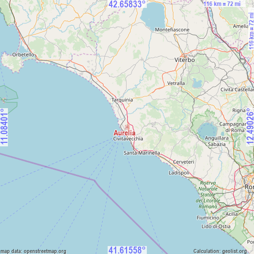
Aurelia GPS coordinates[2]
42° 8' 20.76" North, 11° 47' 13.668" East
| Map corner | latitude | longitude |
|---|---|---|
| Upper-left | 42.65833°, | 11.08401° |
| Center: | 42.1391°, | 11.78713° |
| Lower-right: | 41.61558°, | 12.49026° |
| Map W x H: | 115.9×115.9 km | = 72×72mi |
| max Lat: | 47.04031° ⇑69.1% North |
| Aurelia: | 42.1391° |
| min Lat: | ⇓30.9% South 35.50142° |
| min Long | Aurelia | max Long |
| 6.69888° | 11.78713° | 18.48682° |
| W 52.9%⇐ | ⇒47.1% E |
Elevation
Elevation of Aurelia is 65 m = 213 ft, and this is 241.7 m = 793 ft below average elevation for this country.
| Max E: |
2085 m = 6841 ft | 76.8% |
| Avg. | 306.7 m = 1006 ft | |
| Aurelia | 65 m = 213 ft | |
Min E: |
-4 m = -13 ft | 23.2% |
See also: Italy elevation on elevation.city.
Geographical zone
Aurelia is located in North temperate zone (between Tropic of Cancer and the Arctic Circle). Distance of this Northern Tropic circle is 2079.5 km =1292.1 mi to South.| Distance of | km | miles | from Aurelia |
|---|---|---|---|
| North Pole | 5321.6 | 3306.7 | to North |
| Arctic Circle | 2715.7 | 1687.5 | to North |
| Tropic Cancer | 2079.5 | 1292.1 | to South |
| Equator | 4685.4 | 2911.4 | to South |


Nearby cities:
15 places around Aurelia: (largest is in red/bold)
• Allumiere
9.8 km =6.1 mi,  77°
77°
• Barbarano Romano
26.2 km =16.3 mi,  62°
62°
• Blera
24.9 km =15.5 mi,  53°
53°
• Canale Monterano
26 km =16.2 mi,  90°
90°
• Civitavecchia
5.2 km =3.2 mi,  171°
171°
• Lido di Tarquinia
11.4 km =7.1 mi,  324°
324°
• Monte Romano
16.9 km =10.5 mi,  32°
32°
• Prato del Mare
10.7 km =6.6 mi,  160°
160°
• Santa Marinella
12.9 km =8 mi,  154°
154°
• Santa Severa
18.5 km =11.5 mi,  133°
133°
• Santa Severa Nord
20 km =12.4 mi, 130°
• Tarquinia
13 km =8.1 mi,  348°
348°
• Tolfa
12 km =7.5 mi, 84°
• Vejano
26.8 km =16.7 mi,  70°
70°
• Villa San Giovanni in Tuscia
26.9 km =16.7 mi, 54°
Sources, notices
• [Note1] Compared only with cities in Italy existing in our database
• [Src1] Map data: © OpenStreetMap contributors (CC-BY-SA)
• [Src2] Other city data from geonames.org with taken over terms of usage.
• [Src3] Geographical zone / Annual Mean Temperature by Robert A. Rohde @ Wikipedia
