Susegana geodata
Susegana (Veneto) is a seat of a third-order administrative division; located in Italy in Europe/Rome (GMT+2) time zone. With population of 3,414 people, there are 2746 cities with bigger population in this country. Compared to other cities in Italy, 87.8% of cities are located further ↓South; 59.4% of cities are located further ←West and 76.1% of cities have higher elevation than Susegana. Note1


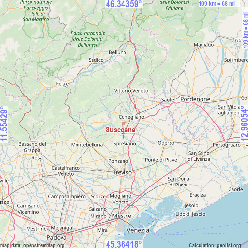
Susegana GPS coordinates[2]
45° 51' 21.744" North, 12° 15' 26.676" East
| Map corner | latitude | longitude |
|---|---|---|
| Upper-left | 46.34359°, | 11.55429° |
| Center: | 45.85604°, | 12.25741° |
| Lower-right: | 45.36418°, | 12.96054° |
| Map W x H: | 108.9×108.9 km | = 67.7×67.7mi |
| max Lat: | 47.04031° ⇑12.2% North |
| Susegana: | 45.85604° |
| min Lat: | ⇓87.8% South 35.50142° |
| min Long | Susegana | max Long |
| 6.69888° | 12.25741° | 18.48682° |
| W 59.4%⇐ | ⇒40.6% E |
Elevation
Elevation of Susegana is 69 m = 226 ft, and this is 237.7 m = 780 ft below average elevation for this country.
| Max E: |
2085 m = 6841 ft | 76.1% |
| Avg. | 306.7 m = 1006 ft | |
| Susegana | 69 m = 226 ft | |
Min E: |
-4 m = -13 ft | 23.9% |
See also: Italy elevation on elevation.city.
Geographical zone
Susegana is located in North temperate zone (between Tropic of Cancer and the Arctic Circle). Distance of this North polar circle is 2302.5 km =1430.7 mi to North.| Distance of | km | miles | from Susegana |
|---|---|---|---|
| North Pole | 4908.3 | 3049.9 | to North |
| Arctic Circle | 2302.5 | 1430.7 | to North |
| Tropic Cancer | 2492.8 | 1549 | to South |
| Equator | 5098.7 | 3168.2 | to South |


Nearby cities:
15 places around Susegana: (largest is in red/bold)
• Bagnolo
6.2 km =3.9 mi,  11°
11°
• Barbisano
6.2 km =3.9 mi,  297°
297°
• Bidasio
5.1 km =3.2 mi,  194°
194°
• Conegliano
5 km =3.1 mi,  44°
44°
• Falzè di Piave
6.2 km =3.9 mi,  282°
282°
• Mareno di Piave
6.3 km =3.9 mi,  100°
100°
• Moro
5.9 km =3.7 mi,  19°
19°
• Nervesa della Battaglia
6.7 km =4.2 mi,  223°
223°
• Priula-Colfosco
4 km =2.5 mi,  178°
178°
• Saccon
7.4 km =4.6 mi,  74°
74°
• San Pietro di Feletto
6.5 km =4 mi,  355°
355°
• San Vendemiano
8.1 km =5 mi,  64°
64°
• San Vendemiano-Fossamerlo
6.9 km =4.3 mi,  54°
54°
• Santa Lucia di Piave
2.9 km =1.8 mi,  77°
77°
• Santa Maria
4.8 km =3 mi,  338°
338°
Sources, notices
• [Note1] Compared only with cities in Italy existing in our database
• [Src1] Map data: © OpenStreetMap contributors (CC-BY-SA)
• [Src2] Other city data from geonames.org with taken over terms of usage.
• [Src3] Geographical zone / Annual Mean Temperature by Robert A. Rohde @ Wikipedia
