Nervesa della Battaglia geodata
Nervesa della Battaglia (Veneto) is a seat of a third-order administrative division; located in Italy in Europe/Rome (GMT+2) time zone. With population of 4,349 people, there are 2211 cities with bigger population in this country. Compared to other cities in Italy, 86.3% of cities are located further ↓South; 58.6% of cities are located further ←West and 75.4% of cities have higher elevation than Nervesa della Battaglia. Note1
Administrative division(s):
- Level 1: Veneto
- Level 2: Provincia di Treviso
- Level 3: Nervesa della Battaglia
Current local time in Nervesa della Battaglia:
11:43 PM, WednesdayDifference from your time zone: hours


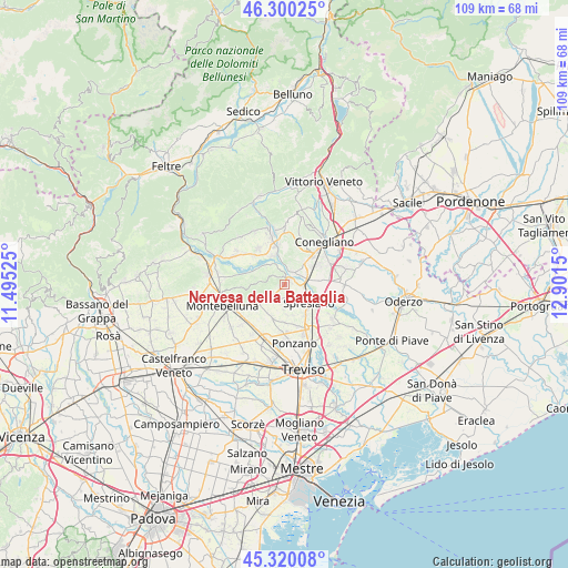
Nervesa della Battaglia GPS coordinates[2]
45° 48' 44.352" North, 12° 11' 54.132" East
| Map corner | latitude | longitude |
|---|---|---|
| Upper-left | 46.30025°, | 11.49525° |
| Center: | 45.81232°, | 12.19837° |
| Lower-right: | 45.32008°, | 12.9015° |
| Map W x H: | 109×109 km | = 67.7×67.7mi |
| max Lat: | 47.04031° ⇑13.7% North |
| Nervesa della Battaglia: | 45.81232° |
| min Lat: | ⇓86.3% South 35.50142° |
| min Long | Nervesa della B | max Long |
| 6.69888° | 12.19837° | 18.48682° |
| W 58.6%⇐ | ⇒41.4% E |
Elevation
Elevation of Nervesa della Battaglia is 72 m = 236 ft, and this is 234.7 m = 770 ft below average elevation for this country.
| Max E: |
2085 m = 6841 ft | 75.4% |
| Avg. | 306.7 m = 1006 ft | |
| Nervesa della Battaglia | 72 m = 236 ft | |
Min E: |
-4 m = -13 ft | 24.6% |
See also: Italy elevation on elevation.city.
Geographical zone
Nervesa della Battaglia is located in North temperate zone (between Tropic of Cancer and the Arctic Circle). Distance of this North polar circle is 2307.3 km =1433.7 mi to North.| Distance of | km | miles | from Nervesa della Battaglia |
|---|---|---|---|
| North Pole | 4913.2 | 3052.9 | to North |
| Arctic Circle | 2307.3 | 1433.7 | to North |
| Tropic Cancer | 2487.9 | 1545.9 | to South |
| Equator | 5093.9 | 3165.2 | to South |


Nearby cities:
15 places around Nervesa della Battaglia: (largest is in red/bold)
• Arcade
3.5 km =2.2 mi,  152°
152°
• Barbisano
7.8 km =4.8 mi,  353°
353°
• Bidasio
3.3 km =2.1 mi,  91°
91°
• Camalò
6.9 km =4.3 mi,  197°
197°
• Falzè di Piave
6.4 km =4 mi, 346°
• Giavera del Montello
3.2 km =2 mi,  229°
229°
• Povegliano
5.9 km =3.7 mi,  171°
171°
• Priula-Colfosco
4.7 km =2.9 mi,  79°
79°
• San Rocco
4.5 km =2.8 mi,  182°
182°
• Santandrà
7.2 km =4.5 mi, 178°
• Selva del Montello
5 km =3.1 mi,  237°
237°
• Spresiano
5.8 km =3.6 mi,  129°
129°
• Susegana
6.7 km =4.2 mi,  43°
43°
• Visnadello
7 km =4.3 mi, 147°
• Volpago del Montello
7.3 km =4.5 mi, 238°
Sources, notices
• [Note1] Compared only with cities in Italy existing in our database
• [Src1] Map data: © OpenStreetMap contributors (CC-BY-SA)
• [Src2] Other city data from geonames.org with taken over terms of usage.
• [Src3] Geographical zone / Annual Mean Temperature by Robert A. Rohde @ Wikipedia
