Staggia geodata
Staggia (Tuscany) is a populated place; located in Italy in Europe/Rome (GMT+2) time zone. With population of 2,548 people, there are 3467 cities with bigger population in this country. Compared to other cities in Italy, 60.4% of cities are located further ↑North; 54.6% of cities are located further →East and 58.5% of cities have higher elevation than Staggia. Note1


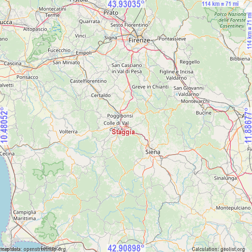
Staggia GPS coordinates[2]
43° 25' 18.552" North, 11° 11' 1.104" East
| Map corner | latitude | longitude |
|---|---|---|
| Upper-left | 43.93035°, | 10.48052° |
| Center: | 43.42182°, | 11.18364° |
| Lower-right: | 42.90898°, | 11.88677° |
| Map W x H: | 113.6×113.6 km | = 70.6×70.6mi |
| max Lat: | 47.04031° ⇑60.4% North |
| Staggia: | 43.42182° |
| min Lat: | ⇓39.6% South 35.50142° |
| min Long | Staggia | max Long |
| 6.69888° | 11.18364° | 18.48682° |
| W 45.4%⇐ | ⇒54.6% E |
Elevation
Elevation of Staggia is 175 m = 574 ft, and this is 131.7 m = 432 ft below average elevation for this country.
| Max E: |
2085 m = 6841 ft | 58.5% |
| Avg. | 306.7 m = 1006 ft | |
| Staggia | 175 m = 574 ft | |
Min E: |
-4 m = -13 ft | 41.5% |
See also: Italy elevation on elevation.city.
Geographical zone
Staggia is located in North temperate zone (between Tropic of Cancer and the Arctic Circle). Distance of this Northern Tropic circle is 2222.1 km =1380.7 mi to South.| Distance of | km | miles | from Staggia |
|---|---|---|---|
| North Pole | 5179 | 3218.1 | to North |
| Arctic Circle | 2573.1 | 1598.8 | to North |
| Tropic Cancer | 2222.1 | 1380.7 | to South |
| Equator | 4828.1 | 3000 | to South |


Nearby cities:
15 places around Staggia: (largest is in red/bold)
• Badesse
8.4 km =5.2 mi,  121°
121°
• Barberino Val d'Elsa
13.2 km =8.2 mi,  355°
355°
• Bellavista
2.9 km =1.8 mi,  320°
320°
• Belverde
12.9 km =8 mi,  129°
129°
• Campiglia
8.5 km =5.3 mi,  263°
263°
• Casole d'Elsa
14.2 km =8.8 mi,  230°
230°
• Castellina Scalo
2.8 km =1.7 mi, 132°
• Castellina in Chianti
9.8 km =6.1 mi,  61°
61°
• Colle di Val d'Elsa
4.5 km =2.8 mi,  268°
268°
• Monteriggioni
4.8 km =3 mi,  137°
137°
• Poggibonsi
6.1 km =3.8 mi,  332°
332°
• San Donato
13.5 km =8.4 mi,  17°
17°
• San Gimignano
13.7 km =8.5 mi,  294°
294°
• Tavarnelle Val di Pesa
15.6 km =9.7 mi, 356°
• Ulignano
12.4 km =7.7 mi, 318°
Sources, notices
• [Note1] Compared only with cities in Italy existing in our database
• [Src1] Map data: © OpenStreetMap contributors (CC-BY-SA)
• [Src2] Other city data from geonames.org with taken over terms of usage.
• [Src3] Geographical zone / Annual Mean Temperature by Robert A. Rohde @ Wikipedia
