Tavarnelle Val di Pesa geodata
Tavarnelle Val di Pesa (Tuscany) is a seat of a third-order administrative division; located in Italy in Europe/Rome (GMT+2) time zone. With population of 7,153 people, there are 1371 cities with bigger population in this country. Compared to other cities in Italy, 59.3% of cities are located further ↑North; 54.8% of cities are located further →East and 67.3% of cities have lower elevation than Tavarnelle Val di Pesa. Note1
Administrative division(s):
- Level 1: Tuscany
- Level 2: Province of Florence
- Level 3: Barberino Tavarnelle
Current local time in Tavarnelle Val di Pesa:
05:02 PM, WednesdayDifference from your time zone: hours


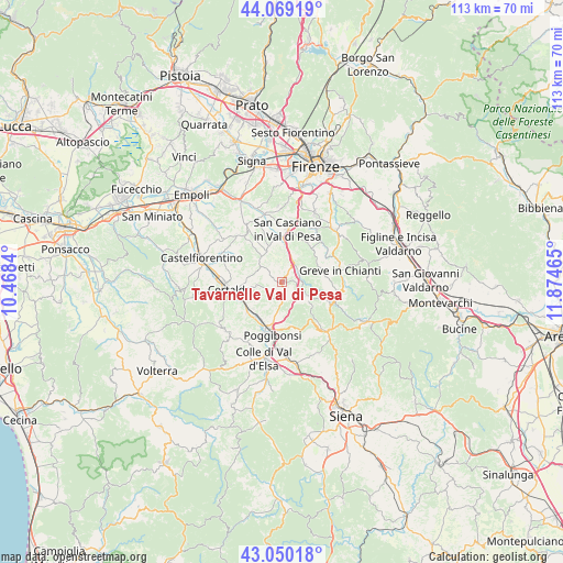
Tavarnelle Val di Pesa GPS coordinates[2]
43° 33' 42.624" North, 11° 10' 17.472" East
| Map corner | latitude | longitude |
|---|---|---|
| Upper-left | 44.06919°, | 10.4684° |
| Center: | 43.56184°, | 11.17152° |
| Lower-right: | 43.05018°, | 11.87465° |
| Map W x H: | 113.3×113.3 km | = 70.4×70.4mi |
| max Lat: | 47.04031° ⇑59.3% North |
| Tavarnelle Val di Pesa: | 43.56184° |
| min Lat: | ⇓40.7% South 35.50142° |
| min Long | Tavarnelle Val | max Long |
| 6.69888° | 11.17152° | 18.48682° |
| W 45.2%⇐ | ⇒54.8% E |
Elevation
Elevation of Tavarnelle Val di Pesa is 366 m = 1201 ft, and this is 59.3 m = 195 ft above average elevation for this country.
| Max E: |
2085 m = 6841 ft | 32.7% |
| Tavarnelle Val di Pesa | 366 m 1201 ft | |
| Avg. | 306.7 m = 1006 ft | |
Min E: |
-4 m = -13 ft | 67.3% |
See also: Italy elevation on elevation.city.
Geographical zone
Tavarnelle Val di Pesa is located in North temperate zone (between Tropic of Cancer and the Arctic Circle). Distance of this Northern Tropic circle is 2237.7 km =1390.4 mi to South.| Distance of | km | miles | from Tavarnelle Val di Pesa |
|---|---|---|---|
| North Pole | 5163.4 | 3208.4 | to North |
| Arctic Circle | 2557.6 | 1589.2 | to North |
| Tropic Cancer | 2237.7 | 1390.4 | to South |
| Equator | 4843.6 | 3009.7 | to South |


Nearby cities:
15 places around Tavarnelle Val di Pesa: (largest is in red/bold)
• Badia A Elmi
11.5 km =7.1 mi,  257°
257°
• Badia a Cerreto
11.9 km =7.4 mi, 261°
• Barberino Val d'Elsa
2.4 km =1.5 mi,  179°
179°
• Bellavista
13.4 km =8.3 mi, 183°
• Certaldo
10.8 km =6.7 mi, 261°
• Greve in Chianti
12 km =7.5 mi,  77°
77°
• Mercatale
9.5 km =5.9 mi,  28°
28°
• Montespertoli
12 km =7.5 mi,  318°
318°
• Panzano in Chianti
11.7 km =7.3 mi,  99°
99°
• Poggibonsi
10.3 km =6.4 mi,  190°
190°
• Sambuca
3.7 km =2.3 mi,  69°
69°
• San Casciano in Val di Pesa
10.9 km =6.8 mi,  5°
5°
• San Donato
5.8 km =3.6 mi,  118°
118°
• San Quirico in Collina
10.5 km =6.5 mi,  339°
339°
• Ulignano
9.6 km =6 mi,  229°
229°
Sources, notices
• [Note1] Compared only with cities in Italy existing in our database
• [Src1] Map data: © OpenStreetMap contributors (CC-BY-SA)
• [Src2] Other city data from geonames.org with taken over terms of usage.
• [Src3] Geographical zone / Annual Mean Temperature by Robert A. Rohde @ Wikipedia
