Ulignano geodata
Ulignano (Tuscany) is a populated place; located in Italy in Europe/Rome (GMT+2) time zone. With population of 506 people, there are 9871 cities with bigger population in this country. Compared to other cities in Italy, 59.8% of cities are located further ↑North; 56.2% of cities are located further →East and 68.3% of cities have higher elevation than Ulignano. Note1


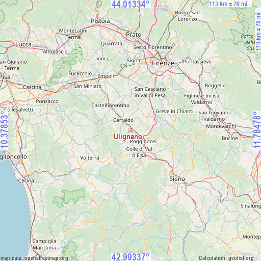
Ulignano GPS coordinates[2]
43° 30' 19.836" North, 11° 4' 53.94" East
| Map corner | latitude | longitude |
|---|---|---|
| Upper-left | 44.01334°, | 10.37853° |
| Center: | 43.50551°, | 11.08165° |
| Lower-right: | 42.99337°, | 11.78478° |
| Map W x H: | 113.4×113.4 km | = 70.5×70.5mi |
| max Lat: | 47.04031° ⇑59.8% North |
| Ulignano: | 43.50551° |
| min Lat: | ⇓40.2% South 35.50142° |
| min Long | Ulignano | max Long |
| 6.69888° | 11.08165° | 18.48682° |
| W 43.8%⇐ | ⇒56.2% E |
Elevation
Elevation of Ulignano is 107 m = 351 ft, and this is 199.7 m = 655 ft below average elevation for this country.
| Max E: |
2085 m = 6841 ft | 68.3% |
| Avg. | 306.7 m = 1006 ft | |
| Ulignano | 107 m = 351 ft | |
Min E: |
-4 m = -13 ft | 31.7% |
See also: Italy elevation on elevation.city.
Geographical zone
Ulignano is located in North temperate zone (between Tropic of Cancer and the Arctic Circle). Distance of this Northern Tropic circle is 2231.4 km =1386.5 mi to South.| Distance of | km | miles | from Ulignano |
|---|---|---|---|
| North Pole | 5169.7 | 3212.3 | to North |
| Arctic Circle | 2563.8 | 1593.1 | to North |
| Tropic Cancer | 2231.4 | 1386.5 | to South |
| Equator | 4837.4 | 3005.8 | to South |


Nearby cities:
15 places around Ulignano: (largest is in red/bold)
• Badia A Elmi
5.4 km =3.4 mi,  312°
312°
• Badia a Cerreto
6.4 km =4 mi, 314°
• Barberino Val d'Elsa
8.2 km =5.1 mi,  62°
62°
• Bellavista
9.5 km =5.9 mi,  137°
137°
• Campiglia
10.2 km =6.3 mi,  181°
181°
• Case Nuove
12.5 km =7.8 mi, 311°
• Certaldo
5.8 km =3.6 mi,  323°
323°
• Colle di Val d'Elsa
10.1 km =6.3 mi,  158°
158°
• Gambassi Terme
11 km =6.8 mi,  287°
287°
• Poggibonsi
6.6 km =4.1 mi,  125°
125°
• Sambuca
13.1 km =8.1 mi,  54°
54°
• San Donato
12.8 km =8 mi,  74°
74°
• San Gimignano
5.5 km =3.4 mi,  229°
229°
• Staggia
12.4 km =7.7 mi, 138°
• Tavarnelle Val di Pesa
9.6 km =6 mi, 49°
Sources, notices
• [Note1] Compared only with cities in Italy existing in our database
• [Src1] Map data: © OpenStreetMap contributors (CC-BY-SA)
• [Src2] Other city data from geonames.org with taken over terms of usage.
• [Src3] Geographical zone / Annual Mean Temperature by Robert A. Rohde @ Wikipedia
