Sossano geodata
Sossano (Veneto) is a seat of a third-order administrative division; located in Italy in Europe/Rome (GMT+2) time zone. With population of 2,902 people, there are 3118 cities with bigger population in this country. Compared to other cities in Italy, 69% of cities are located further ↓South; 50.5% of cities are located further →East and 89.6% of cities have higher elevation than Sossano. Note1


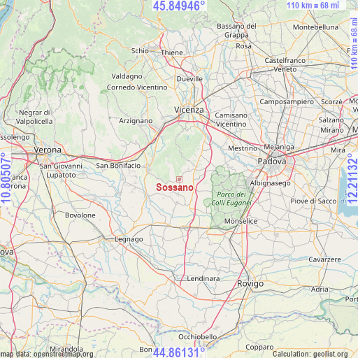
Sossano GPS coordinates[2]
45° 21' 27.144" North, 11° 30' 29.484" East
| Map corner | latitude | longitude |
|---|---|---|
| Upper-left | 45.84946°, | 10.80507° |
| Center: | 45.35754°, | 11.50819° |
| Lower-right: | 44.86131°, | 12.21132° |
| Map W x H: | 109.9×109.9 km | = 68.3×68.3mi |
| max Lat: | 47.04031° ⇑31% North |
| Sossano: | 45.35754° |
| min Lat: | ⇓69% South 35.50142° |
| min Long | Sossano | max Long |
| 6.69888° | 11.50819° | 18.48682° |
| W 49.5%⇐ | ⇒50.5% E |
Elevation
Elevation of Sossano is 19 m = 62 ft, and this is 287.7 m = 944 ft below average elevation for this country.
| Max E: |
2085 m = 6841 ft | 89.6% |
| Avg. | 306.7 m = 1006 ft | |
| Sossano | 19 m = 62 ft | |
Min E: |
-4 m = -13 ft | 10.4% |
See also: Italy elevation on elevation.city.
Geographical zone
Sossano is located in North temperate zone (between Tropic of Cancer and the Arctic Circle). Distance of this North polar circle is 2357.9 km =1465.1 mi to North.| Distance of | km | miles | from Sossano |
|---|---|---|---|
| North Pole | 4963.8 | 3084.4 | to North |
| Arctic Circle | 2357.9 | 1465.1 | to North |
| Tropic Cancer | 2437.4 | 1514.5 | to South |
| Equator | 5043.3 | 3133.8 | to South |


Nearby cities:
15 places around Sossano: (largest is in red/bold)
• Agugliaro
7 km =4.3 mi,  121°
121°
• Albettone
5.9 km =3.7 mi,  89°
89°
• Alonte
6.4 km =4 mi,  278°
278°
• Asigliano Veneto
7.6 km =4.7 mi,  219°
219°
• Barbarano Vicentino
6.4 km =4 mi,  25°
25°
• Cagnano
4.8 km =3 mi,  184°
184°
• Campiglia dei Berici
3.6 km =2.2 mi,  132°
132°
• Mossano
7.8 km =4.8 mi, 27°
• Noventa Vicentina
7.7 km =4.8 mi,  155°
155°
• Orgiano
4.6 km =2.9 mi,  235°
235°
• Poiana Maggiore
7.5 km =4.7 mi, 183°
• Ponte di Barbarano
6.7 km =4.2 mi,  55°
55°
• San Germano dei Berici
5.7 km =3.5 mi,  329°
329°
• Villaga
5.4 km =3.4 mi,  22°
22°
• Zovencedo
7.9 km =4.9 mi,  357°
357°
Sources, notices
• [Note1] Compared only with cities in Italy existing in our database
• [Src1] Map data: © OpenStreetMap contributors (CC-BY-SA)
• [Src2] Other city data from geonames.org with taken over terms of usage.
• [Src3] Geographical zone / Annual Mean Temperature by Robert A. Rohde @ Wikipedia
