Alonte geodata
Alonte (Veneto) is a seat of a third-order administrative division; located in Italy in Europe/Rome (GMT+2) time zone. With population of 689 people, there are 8372 cities with bigger population in this country. Compared to other cities in Italy, 69.3% of cities are located further ↓South; 51.6% of cities are located further →East and 83.1% of cities have higher elevation than Alonte. Note1


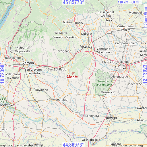
Alonte GPS coordinates[2]
45° 21' 57.204" North, 11° 25' 37.56" East
| Map corner | latitude | longitude |
|---|---|---|
| Upper-left | 45.85773°, | 10.72398° |
| Center: | 45.36589°, | 11.4271° |
| Lower-right: | 44.86973°, | 12.13023° |
| Map W x H: | 109.9×109.9 km | = 68.3×68.3mi |
| max Lat: | 47.04031° ⇑30.7% North |
| Alonte: | 45.36589° |
| min Lat: | ⇓69.3% South 35.50142° |
| min Long | Alonte | max Long |
| 6.69888° | 11.4271° | 18.48682° |
| W 48.4%⇐ | ⇒51.6% E |
Elevation
Elevation of Alonte is 37 m = 121 ft, and this is 269.7 m = 885 ft below average elevation for this country.
| Max E: |
2085 m = 6841 ft | 83.1% |
| Avg. | 306.7 m = 1006 ft | |
| Alonte | 37 m = 121 ft | |
Min E: |
-4 m = -13 ft | 16.9% |
See also: Italy elevation on elevation.city.
Geographical zone
Alonte is located in North temperate zone (between Tropic of Cancer and the Arctic Circle). Distance of this North polar circle is 2357 km =1464.6 mi to North.| Distance of | km | miles | from Alonte |
|---|---|---|---|
| North Pole | 4962.8 | 3083.7 | to North |
| Arctic Circle | 2357 | 1464.6 | to North |
| Tropic Cancer | 2438.3 | 1515.1 | to South |
| Equator | 5044.2 | 3134.3 | to South |


Nearby cities:
15 places around Alonte: (largest is in red/bold)
• Asigliano Veneto
7 km =4.3 mi,  167°
167°
• Bagnolo
4.2 km =2.6 mi,  257°
257°
• Cagnano
8.3 km =5.2 mi,  133°
133°
• Cologna Veneta
7.4 km =4.6 mi,  209°
209°
• Grancona
6.5 km =4 mi,  17°
17°
• Lonigo
4 km =2.5 mi,  303°
303°
• Meledo
8.1 km =5 mi,  353°
353°
• Monticello di Fara
7.6 km =4.7 mi,  337°
337°
• Orgiano
4.4 km =2.7 mi,  144°
144°
• Pederiva
7 km =4.3 mi,  25°
25°
• San Germano dei Berici
5.3 km =3.3 mi,  40°
40°
• Santo Stefano-Bonaldo
7.4 km =4.6 mi,  271°
271°
• Sarego
5 km =3.1 mi, 337°
• Sossano
6.4 km =4 mi,  98°
98°
• Zimella
5.5 km =3.4 mi,  225°
225°
Sources, notices
• [Note1] Compared only with cities in Italy existing in our database
• [Src1] Map data: © OpenStreetMap contributors (CC-BY-SA)
• [Src2] Other city data from geonames.org with taken over terms of usage.
• [Src3] Geographical zone / Annual Mean Temperature by Robert A. Rohde @ Wikipedia
