Sorano geodata
Sorano (Tuscany) is a seat of a third-order administrative division; located in Italy in Europe/Rome (GMT+2) time zone. With population of 779 people, there are 7764 cities with bigger population in this country. Compared to other cities in Italy, 65.3% of cities are located further ↑North; 52.1% of cities are located further ←West and 71.5% of cities have lower elevation than Sorano. Note1


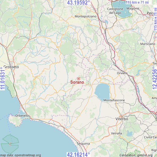
Sorano GPS coordinates[2]
42° 40' 52.248" North, 11° 43' 9.948" East
| Map corner | latitude | longitude |
|---|---|---|
| Upper-left | 43.19592°, | 11.01631° |
| Center: | 42.68118°, | 11.71943° |
| Lower-right: | 42.16214°, | 12.42256° |
| Map W x H: | 114.9×114.9 km | = 71.4×71.4mi |
| max Lat: | 47.04031° ⇑65.3% North |
| Sorano: | 42.68118° |
| min Lat: | ⇓34.7% South 35.50142° |
| min Long | Sorano | max Long |
| 6.69888° | 11.71943° | 18.48682° |
| W 52.1%⇐ | ⇒47.9% E |
Elevation
Elevation of Sorano is 409 m = 1342 ft, and this is 102.3 m = 336 ft above average elevation for this country.
| Max E: |
2085 m = 6841 ft | 28.5% |
| Sorano | 409 m 1342 ft | |
| Avg. | 306.7 m = 1006 ft | |
Min E: |
-4 m = -13 ft | 71.5% |
See also: Italy elevation on elevation.city.
Geographical zone
Sorano is located in North temperate zone (between Tropic of Cancer and the Arctic Circle). Distance of this Northern Tropic circle is 2139.8 km =1329.6 mi to South.| Distance of | km | miles | from Sorano |
|---|---|---|---|
| North Pole | 5261.4 | 3269.3 | to North |
| Arctic Circle | 2655.5 | 1650.1 | to North |
| Tropic Cancer | 2139.8 | 1329.6 | to South |
| Equator | 4745.7 | 2948.8 | to South |


Nearby cities:
15 places around Sorano: (largest is in red/bold)
• Acquapendente
13.9 km =8.6 mi,  60°
60°
• Castell'Azzara
10.3 km =6.4 mi,  350°
350°
• Farnese
14.7 km =9.1 mi,  177°
177°
• Gradoli
11.9 km =7.4 mi,  109°
109°
• Grotte di Castro
12.2 km =7.6 mi,  92°
92°
• Ischia di Castro
15.5 km =9.6 mi,  168°
168°
• Latera
10.7 km =6.6 mi,  122°
122°
• Manciano
19.4 km =12.1 mi,  238°
238°
• Onano
7.9 km =4.9 mi,  82°
82°
• Piancastagnaio
19 km =11.8 mi, 352°
• Pitigliano
6.2 km =3.9 mi,  215°
215°
• Proceno
12.3 km =7.6 mi,  46°
46°
• San Lorenzo Nuovo
15.4 km =9.6 mi, 87°
• Semproniano
15.5 km =9.6 mi,  290°
290°
• Valentano
15.8 km =9.8 mi,  145°
145°
Sources, notices
• [Note1] Compared only with cities in Italy existing in our database
• [Src1] Map data: © OpenStreetMap contributors (CC-BY-SA)
• [Src2] Other city data from geonames.org with taken over terms of usage.
• [Src3] Geographical zone / Annual Mean Temperature by Robert A. Rohde @ Wikipedia
