Acquapendente geodata
Acquapendente (Latium) is a seat of a third-order administrative division; located in Italy in Europe/Rome (GMT+2) time zone. With population of 4,158 people, there are 2310 cities with bigger population in this country. Compared to other cities in Italy, 65% of cities are located further ↑North; 54.1% of cities are located further ←West and 69.4% of cities have lower elevation than Acquapendente. Note1


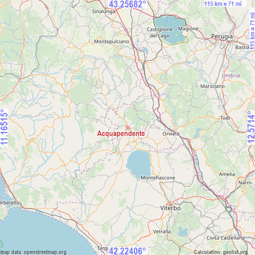
Acquapendente GPS coordinates[2]
42° 44' 33.324" North, 11° 52' 5.772" East
| Map corner | latitude | longitude |
|---|---|---|
| Upper-left | 43.25682°, | 11.16515° |
| Center: | 42.74259°, | 11.86827° |
| Lower-right: | 42.22406°, | 12.5714° |
| Map W x H: | 114.8×114.8 km | = 71.3×71.3mi |
| max Lat: | 47.04031° ⇑65% North |
| Acquapendente: | 42.74259° |
| min Lat: | ⇓35% South 35.50142° |
| min Long | Acquapendente | max Long |
| 6.69888° | 11.86827° | 18.48682° |
| W 54.1%⇐ | ⇒45.9% E |
Elevation
Elevation of Acquapendente is 388 m = 1273 ft, and this is 81.3 m = 267 ft above average elevation for this country.
| Max E: |
2085 m = 6841 ft | 30.6% |
| Acquapendente | 388 m 1273 ft | |
| Avg. | 306.7 m = 1006 ft | |
Min E: |
-4 m = -13 ft | 69.4% |
See also: Italy elevation on elevation.city.
Geographical zone
Acquapendente is located in North temperate zone (between Tropic of Cancer and the Arctic Circle). Distance of this Northern Tropic circle is 2146.6 km =1333.8 mi to South.| Distance of | km | miles | from Acquapendente |
|---|---|---|---|
| North Pole | 5254.5 | 3265 | to North |
| Arctic Circle | 2648.6 | 1645.8 | to North |
| Tropic Cancer | 2146.6 | 1333.8 | to South |
| Equator | 4752.5 | 2953.1 | to South |


Nearby cities:
15 places around Acquapendente: (largest is in red/bold)
• Allerona
11.6 km =7.2 mi,  48°
48°
• Castel Giorgio
9.7 km =6 mi,  114°
114°
• Castel Viscardo
10.9 km =6.8 mi,  83°
83°
• Castell'Azzara
14.3 km =8.9 mi,  283°
283°
• Gradoli
10.9 km =6.8 mi,  185°
185°
• Grotte di Castro
7.4 km =4.6 mi,  179°
179°
• Latera
13 km =8.1 mi, 194°
• Monterubiaglio
12.4 km =7.7 mi, 77°
• Onano
7.2 km =4.5 mi,  216°
216°
• Pianlungo
14.3 km =8.9 mi,  72°
72°
• Proceno
3.6 km =2.2 mi,  297°
297°
• San Casciano dei Bagni
14.2 km =8.8 mi,  2°
2°
• San Lorenzo Nuovo
7 km =4.3 mi,  153°
153°
• Sorano
13.9 km =8.6 mi,  240°
240°
• Stazione di Allerona
14.6 km =9.1 mi, 70°
Sources, notices
• [Note1] Compared only with cities in Italy existing in our database
• [Src1] Map data: © OpenStreetMap contributors (CC-BY-SA)
• [Src2] Other city data from geonames.org with taken over terms of usage.
• [Src3] Geographical zone / Annual Mean Temperature by Robert A. Rohde @ Wikipedia
