Solofra geodata
Solofra (Campania) is a seat of a third-order administrative division; located in Italy in Europe/Rome (GMT+1) time zone. With population of 11,886 people, there are 782 cities with bigger population in this country. Compared to other cities in Italy, 81% of cities are located further ↑North; 85.8% of cities are located further ←West and 65.3% of cities have lower elevation than Solofra. Note1


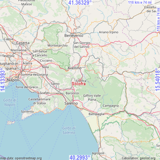
Solofra GPS coordinates[2]
40° 50' 0.348" North, 14° 50' 13.38" East
| Map corner | latitude | longitude |
|---|---|---|
| Upper-left | 41.36329°, | 14.13393° |
| Center: | 40.83343°, | 14.83705° |
| Lower-right: | 40.2993°, | 15.54018° |
| Map W x H: | 118.3×118.3 km | = 73.5×73.5mi |
| max Lat: | 47.04031° ⇑81% North |
| Solofra: | 40.83343° |
| min Lat: | ⇓19% South 35.50142° |
| min Long | Solofra | max Long |
| 6.69888° | 14.83705° | 18.48682° |
| W 85.8%⇐ | ⇒14.2% E |
Elevation
Elevation of Solofra is 346 m = 1135 ft, and this is 39.3 m = 129 ft above average elevation for this country.
| Max E: |
2085 m = 6841 ft | 34.7% |
| Solofra | 346 m 1135 ft | |
| Avg. | 306.7 m = 1006 ft | |
Min E: |
-4 m = -13 ft | 65.3% |
See also: Italy elevation on elevation.city.
Geographical zone
Solofra is located in North temperate zone (between Tropic of Cancer and the Arctic Circle). Distance of this Northern Tropic circle is 1934.3 km =1201.9 mi to South.| Distance of | km | miles | from Solofra |
|---|---|---|---|
| North Pole | 5466.8 | 3396.9 | to North |
| Arctic Circle | 2860.9 | 1777.7 | to North |
| Tropic Cancer | 1934.3 | 1201.9 | to South |
| Equator | 4540.3 | 2821.2 | to South |


Nearby cities:
15 places around Solofra: (largest is in red/bold)
• Aiello del Sabato
6.3 km =3.9 mi,  347°
347°
• Banzano
3.2 km =2 mi,  290°
290°
• Borgo
4.6 km =2.9 mi,  279°
279°
• Calvanico
6.4 km =4 mi,  187°
187°
• Contrada
6.3 km =3.9 mi,  307°
307°
• Labso
6 km =3.7 mi, 280°
• Misciano
4.7 km =2.9 mi,  244°
244°
• Montoro Superiore
3.7 km =2.3 mi, 240°
• Piazza di Pandola
6.2 km =3.9 mi, 242°
• Sala
3.9 km =2.4 mi,  51°
51°
• San Michele di Serino
4.9 km =3 mi,  17°
17°
• San Pietro
4.5 km =2.8 mi,  256°
256°
• Santa Lucia di Serino
5.3 km =3.3 mi,  38°
38°
• Serino
3.8 km =2.4 mi, 51°
• Torchiati
3.4 km =2.1 mi, 240°
Sources, notices
• [Note1] Compared only with cities in Italy existing in our database
• [Src1] Map data: © OpenStreetMap contributors (CC-BY-SA)
• [Src2] Other city data from geonames.org with taken over terms of usage.
• [Src3] Geographical zone / Annual Mean Temperature by Robert A. Rohde @ Wikipedia
