Solagna geodata
Solagna (Veneto) is a seat of a third-order administrative division; located in Italy in Europe/Rome (GMT+2) time zone. With population of 1,659 people, there are 4760 cities with bigger population in this country. Compared to other cities in Italy, 86.6% of cities are located further ↓South; 52.1% of cities are located further ←West and 63.9% of cities have higher elevation than Solagna. Note1


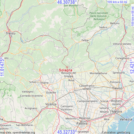
Solagna GPS coordinates[2]
45° 49' 10.236" North, 11° 43' 4.332" East
| Map corner | latitude | longitude |
|---|---|---|
| Upper-left | 46.30738°, | 11.01475° |
| Center: | 45.81951°, | 11.71787° |
| Lower-right: | 45.32733°, | 12.421° |
| Map W x H: | 109×109 km | = 67.7×67.7mi |
| max Lat: | 47.04031° ⇑13.4% North |
| Solagna: | 45.81951° |
| min Lat: | ⇓86.6% South 35.50142° |
| min Long | Solagna | max Long |
| 6.69888° | 11.71787° | 18.48682° |
| W 52.1%⇐ | ⇒47.9% E |
Elevation
Elevation of Solagna is 135 m = 443 ft, and this is 171.7 m = 563 ft below average elevation for this country.
| Max E: |
2085 m = 6841 ft | 63.9% |
| Avg. | 306.7 m = 1006 ft | |
| Solagna | 135 m = 443 ft | |
Min E: |
-4 m = -13 ft | 36.1% |
See also: Italy elevation on elevation.city.
Geographical zone
Solagna is located in North temperate zone (between Tropic of Cancer and the Arctic Circle). Distance of this North polar circle is 2306.5 km =1433.2 mi to North.| Distance of | km | miles | from Solagna |
|---|---|---|---|
| North Pole | 4912.4 | 3052.4 | to North |
| Arctic Circle | 2306.5 | 1433.2 | to North |
| Tropic Cancer | 2488.7 | 1546.4 | to South |
| Equator | 5094.7 | 3165.7 | to South |


Nearby cities:
15 places around Solagna: (largest is in red/bold)
• Bassano del Grappa
5.9 km =3.7 mi,  172°
172°
• Borso del Grappa
4.4 km =2.7 mi,  103°
103°
• Campese
1.6 km =1 mi,  194°
194°
• Campolongo sul Brenta
1.6 km =1 mi,  302°
302°
• Conco
8.7 km =5.4 mi,  255°
255°
• Liedolo
8.5 km =5.3 mi,  110°
110°
• Mussolente
8.2 km =5.1 mi,  123°
123°
• Pove del Grappa
2.5 km =1.6 mi,  158°
158°
• Romano d'Ezzelino
5.9 km =3.7 mi,  140°
140°
• San Michele
5.1 km =3.2 mi,  203°
203°
• San Nazario
3.2 km =2 mi,  315°
315°
• San Zeno-San Giuseppe
7.7 km =4.8 mi,  153°
153°
• Sant'Eulalia
7.6 km =4.7 mi,  92°
92°
• Valrovina
4.2 km =2.6 mi,  212°
212°
• Valstagna
5.3 km =3.3 mi,  311°
311°
Sources, notices
• [Note1] Compared only with cities in Italy existing in our database
• [Src1] Map data: © OpenStreetMap contributors (CC-BY-SA)
• [Src2] Other city data from geonames.org with taken over terms of usage.
• [Src3] Geographical zone / Annual Mean Temperature by Robert A. Rohde @ Wikipedia
