San Zeno-San Giuseppe geodata
San Zeno-San Giuseppe (Veneto) is a populated place; located in Italy in Europe/Rome (GMT+2) time zone. With population of 9,334 people, there are 1011 cities with bigger population in this country. Compared to other cities in Italy, 83.9% of cities are located further ↓South; 52.6% of cities are located further ←West and 66.7% of cities have higher elevation than San Zeno-San Giuseppe. Note1
Current local time in San Zeno-San Giuseppe:
10:57 PM, WednesdayDifference from your time zone: hours


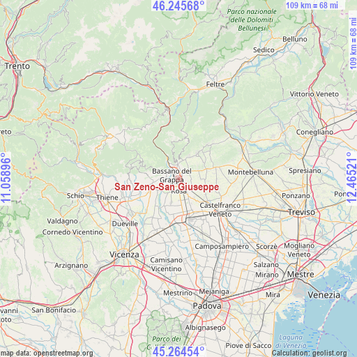
San Zeno-San Giuseppe GPS coordinates[2]
45° 45' 26.172" North, 11° 45' 43.488" East
| Map corner | latitude | longitude |
|---|---|---|
| Upper-left | 46.24568°, | 11.05896° |
| Center: | 45.75727°, | 11.76208° |
| Lower-right: | 45.26454°, | 12.46521° |
| Map W x H: | 109.1×109.1 km | = 67.8×67.8mi |
| max Lat: | 47.04031° ⇑16.1% North |
| San Zeno-San Giuseppe: | 45.75727° |
| min Lat: | ⇓83.9% South 35.50142° |
| min Long | San Zeno-San Gi | max Long |
| 6.69888° | 11.76208° | 18.48682° |
| W 52.6%⇐ | ⇒47.4% E |
Elevation
Elevation of San Zeno-San Giuseppe is 117 m = 384 ft, and this is 189.7 m = 622 ft below average elevation for this country.
| Max E: |
2085 m = 6841 ft | 66.7% |
| Avg. | 306.7 m = 1006 ft | |
| San Zeno-San Giuseppe | 117 m = 384 ft | |
Min E: |
-4 m = -13 ft | 33.3% |
See also: Italy elevation on elevation.city.
Geographical zone
San Zeno-San Giuseppe is located in North temperate zone (between Tropic of Cancer and the Arctic Circle). Distance of this North polar circle is 2313.4 km =1437.5 mi to North.| Distance of | km | miles | from San Zeno-San Giuseppe |
|---|---|---|---|
| North Pole | 4919.3 | 3056.7 | to North |
| Arctic Circle | 2313.4 | 1437.5 | to North |
| Tropic Cancer | 2481.8 | 1542.1 | to South |
| Equator | 5087.7 | 3161.3 | to South |


Nearby cities:
15 places around San Zeno-San Giuseppe: (largest is in red/bold)
• Bassano del Grappa
2.9 km =1.8 mi,  291°
291°
• Borso del Grappa
6 km =3.7 mi,  8°
8°
• Campese
6.6 km =4.1 mi,  324°
324°
• Casoni
3.8 km =2.4 mi,  86°
86°
• Cassola
3.9 km =2.4 mi,  132°
132°
• Liedolo
6 km =3.7 mi,  49°
49°
• Mussolente
4.2 km =2.6 mi, 54°
• Pove del Grappa
5.2 km =3.2 mi,  331°
331°
• Romano d'Ezzelino
2.4 km =1.5 mi, 8°
• Rossano Veneto
6.8 km =4.2 mi,  151°
151°
• Rosà
6.1 km =3.8 mi,  180°
180°
• Sacro Cuore
2.7 km =1.7 mi,  106°
106°
• San Michele
5.9 km =3.7 mi, 291°
• San Zenone degli Ezzelini
6.4 km =4 mi,  66°
66°
• Valrovina
6.6 km =4.1 mi,  300°
300°
Sources, notices
• [Note1] Compared only with cities in Italy existing in our database
• [Src1] Map data: © OpenStreetMap contributors (CC-BY-SA)
• [Src2] Other city data from geonames.org with taken over terms of usage.
• [Src3] Geographical zone / Annual Mean Temperature by Robert A. Rohde @ Wikipedia
