Valstagna geodata
Valstagna (Veneto) is a seat of a third-order administrative division; located in Italy in Europe/Rome (GMT+2) time zone. With population of 970 people, there are 6778 cities with bigger population in this country. Compared to other cities in Italy, 87.7% of cities are located further ↓South; 51.4% of cities are located further ←West and 62.3% of cities have higher elevation than Valstagna. Note1


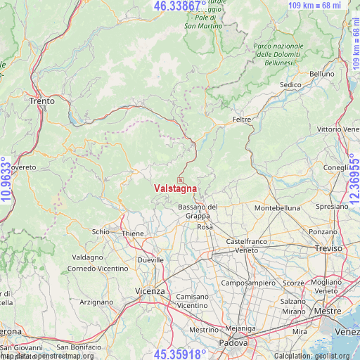
Valstagna GPS coordinates[2]
45° 51' 3.888" North, 11° 39' 59.112" East
| Map corner | latitude | longitude |
|---|---|---|
| Upper-left | 46.33867°, | 10.9633° |
| Center: | 45.85108°, | 11.66642° |
| Lower-right: | 45.35918°, | 12.36955° |
| Map W x H: | 108.9×108.9 km | = 67.7×67.7mi |
| max Lat: | 47.04031° ⇑12.3% North |
| Valstagna: | 45.85108° |
| min Lat: | ⇓87.7% South 35.50142° |
| min Long | Valstagna | max Long |
| 6.69888° | 11.66642° | 18.48682° |
| W 51.4%⇐ | ⇒48.6% E |
Elevation
Elevation of Valstagna is 147 m = 482 ft, and this is 159.7 m = 524 ft below average elevation for this country.
| Max E: |
2085 m = 6841 ft | 62.3% |
| Avg. | 306.7 m = 1006 ft | |
| Valstagna | 147 m = 482 ft | |
Min E: |
-4 m = -13 ft | 37.7% |
See also: Italy elevation on elevation.city.
Geographical zone
Valstagna is located in North temperate zone (between Tropic of Cancer and the Arctic Circle). Distance of this North polar circle is 2303 km =1431 mi to North.| Distance of | km | miles | from Valstagna |
|---|---|---|---|
| North Pole | 4908.9 | 3050.2 | to North |
| Arctic Circle | 2303 | 1431 | to North |
| Tropic Cancer | 2492.2 | 1548.6 | to South |
| Equator | 5098.2 | 3167.9 | to South |


Nearby cities:
15 places around Valstagna: (largest is in red/bold)
• Bassano del Grappa
10.5 km =6.5 mi,  153°
153°
• Borso del Grappa
9.5 km =5.9 mi,  118°
118°
• Campese
6.2 km =3.9 mi,  144°
144°
• Campolongo sul Brenta
3.8 km =2.4 mi, 135°
• Cismon del Grappa
9.1 km =5.7 mi,  31°
31°
• Conco
7.1 km =4.4 mi,  218°
218°
• Enego
10.5 km =6.5 mi,  16°
16°
• Foza
5.8 km =3.6 mi,  331°
331°
• Gallio
10.9 km =6.8 mi,  290°
290°
• Lusiana
10.3 km =6.4 mi, 223°
• Pove del Grappa
7.7 km =4.8 mi, 140°
• San Michele
8.4 km =5.2 mi,  166°
166°
• San Nazario
2.1 km =1.3 mi,  125°
125°
• Solagna
5.3 km =3.3 mi, 131°
• Valrovina
7.3 km =4.5 mi, 166°
Sources, notices
• [Note1] Compared only with cities in Italy existing in our database
• [Src1] Map data: © OpenStreetMap contributors (CC-BY-SA)
• [Src2] Other city data from geonames.org with taken over terms of usage.
• [Src3] Geographical zone / Annual Mean Temperature by Robert A. Rohde @ Wikipedia
