Silla geodata
Silla (Emilia-Romagna) is a populated place; located in Italy in Europe/Rome (GMT+2) time zone. With population of 854 people, there are 7388 cities with bigger population in this country. Compared to other cities in Italy, 52.9% of cities are located further ↑North; 57.6% of cities are located further →East and 65.3% of cities have lower elevation than Silla. Note1


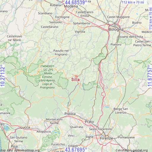
Silla GPS coordinates[2]
44° 10' 59.988" North, 10° 58' 27.984" East
| Map corner | latitude | longitude |
|---|---|---|
| Upper-left | 44.68539°, | 10.27132° |
| Center: | 44.18333°, | 10.97444° |
| Lower-right: | 43.67695°, | 11.67757° |
| Map W x H: | 112.1×112.1 km | = 69.7×69.7mi |
| max Lat: | 47.04031° ⇑52.9% North |
| Silla: | 44.18333° |
| min Lat: | ⇓47.1% South 35.50142° |
| min Long | Silla | max Long |
| 6.69888° | 10.97444° | 18.48682° |
| W 42.4%⇐ | ⇒57.6% E |
Elevation
Elevation of Silla is 346 m = 1135 ft, and this is 39.3 m = 129 ft above average elevation for this country.
| Max E: |
2085 m = 6841 ft | 34.7% |
| Silla | 346 m 1135 ft | |
| Avg. | 306.7 m = 1006 ft | |
Min E: |
-4 m = -13 ft | 65.3% |
See also: Italy elevation on elevation.city.
Geographical zone
Silla is located in North temperate zone (between Tropic of Cancer and the Arctic Circle). Distance of this Northern Tropic circle is 2306.8 km =1433.4 mi to South.| Distance of | km | miles | from Silla |
|---|---|---|---|
| North Pole | 5094.3 | 3165.5 | to North |
| Arctic Circle | 2488.4 | 1546.2 | to North |
| Tropic Cancer | 2306.8 | 1433.4 | to South |
| Equator | 4912.7 | 3052.6 | to South |


Nearby cities:
15 places around Silla: (largest is in red/bold)
• Berzantina
2.9 km =1.8 mi,  169°
169°
• Camugnano
9.2 km =5.7 mi,  98°
98°
• Castel d'Aiano
10.7 km =6.6 mi,  11°
11°
• Castel di Casio
5.3 km =3.3 mi,  115°
115°
• Fanano
14.5 km =9 mi,  282°
282°
• Gaggio Montano
3.4 km =2.1 mi,  293°
293°
• Lizzano in Belvedere
6.9 km =4.3 mi,  249°
249°
• Marano
6.9 km =4.3 mi,  45°
45°
• Molino del Pallone
9.3 km =5.8 mi,  186°
186°
• Montese
9.9 km =6.2 mi,  346°
346°
• Ponte della Venturina
6 km =3.7 mi, 167°
• Porretta Terme
2.2 km =1.4 mi,  180°
180°
• Riola
8.4 km =5.2 mi, 51°
• Sambuca Pistoiese
9 km =5.6 mi, 167°
• Vidiciatico
8 km =5 mi,  259°
259°
Sources, notices
• [Note1] Compared only with cities in Italy existing in our database
• [Src1] Map data: © OpenStreetMap contributors (CC-BY-SA)
• [Src2] Other city data from geonames.org with taken over terms of usage.
• [Src3] Geographical zone / Annual Mean Temperature by Robert A. Rohde @ Wikipedia
