Camugnano geodata
Camugnano (Emilia-Romagna) is a seat of a third-order administrative division; located in Italy in Europe/Rome (GMT+2) time zone. With population of 446 people, there are 10107 cities with bigger population in this country. Compared to other cities in Italy, 53% of cities are located further ↑North; 56.1% of cities are located further →East and 89.4% of cities have lower elevation than Camugnano. Note1


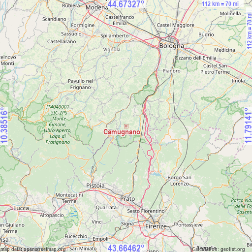
Camugnano GPS coordinates[2]
44° 10' 15.96" North, 11° 5' 17.808" East
| Map corner | latitude | longitude |
|---|---|---|
| Upper-left | 44.67327°, | 10.38516° |
| Center: | 44.1711°, | 11.08828° |
| Lower-right: | 43.66462°, | 11.79141° |
| Map W x H: | 112.2×112.1 km | = 69.7×69.7mi |
| max Lat: | 47.04031° ⇑53% North |
| Camugnano: | 44.1711° |
| min Lat: | ⇓47% South 35.50142° |
| min Long | Camugnano | max Long |
| 6.69888° | 11.08828° | 18.48682° |
| W 43.9%⇐ | ⇒56.1% E |
Elevation
Elevation of Camugnano is 704 m = 2310 ft, and this is 397.3 m = 1303 ft above average elevation for this country.
| Max E: |
2085 m = 6841 ft | 10.6% |
| Camugnano | 704 m 2310 ft | |
| Avg. | 306.7 m = 1006 ft | |
Min E: |
-4 m = -13 ft | 89.4% |
See also: Italy elevation on elevation.city.
Geographical zone
Camugnano is located in North temperate zone (between Tropic of Cancer and the Arctic Circle). Distance of this Northern Tropic circle is 2305.4 km =1432.5 mi to South.| Distance of | km | miles | from Camugnano |
|---|---|---|---|
| North Pole | 5095.7 | 3166.3 | to North |
| Arctic Circle | 2489.8 | 1547.1 | to North |
| Tropic Cancer | 2305.4 | 1432.5 | to South |
| Equator | 4911.4 | 3051.8 | to South |


Nearby cities:
15 places around Camugnano: (largest is in red/bold)
• Baragazza
10.2 km =6.3 mi,  117°
117°
• Berzantina
8.7 km =5.4 mi,  260°
260°
• Castel di Casio
4.3 km =2.7 mi, 257°
• Castiglione dei Pepoli
6.5 km =4 mi, 118°
• Grizzana
11.1 km =6.9 mi,  29°
29°
• Grizzana Morandi
11 km =6.8 mi, 27°
• Lagaro
8.9 km =5.5 mi,  54°
54°
• Marano
7.5 km =4.7 mi,  325°
325°
• Montepiano
10.6 km =6.6 mi,  147°
147°
• Piano del Voglio
10.1 km =6.3 mi,  92°
92°
• Ponte della Venturina
9 km =5.6 mi,  239°
239°
• Porretta Terme
9.1 km =5.7 mi, 264°
• Riola
7 km =4.3 mi,  339°
339°
• Sambuca Pistoiese
10.3 km =6.4 mi,  223°
223°
• Silla
9.2 km =5.7 mi,  278°
278°
Sources, notices
• [Note1] Compared only with cities in Italy existing in our database
• [Src1] Map data: © OpenStreetMap contributors (CC-BY-SA)
• [Src2] Other city data from geonames.org with taken over terms of usage.
• [Src3] Geographical zone / Annual Mean Temperature by Robert A. Rohde @ Wikipedia
