Ponte della Venturina geodata
Ponte della Venturina (Emilia-Romagna) is a populated place; located in Italy in Europe/Rome (GMT+2) time zone. With population of 1,450 people, there are 5245 cities with bigger population in this country. Compared to other cities in Italy, 53.4% of cities are located further ↑North; 57.5% of cities are located further →East and 71.8% of cities have lower elevation than Ponte della Venturina. Note1
Current local time in Ponte della Venturina:
09:34 PM, WednesdayDifference from your time zone: hours


Ponte della Venturina GPS coordinates[2]
44° 7' 49.512" North, 10° 59' 28.068" East
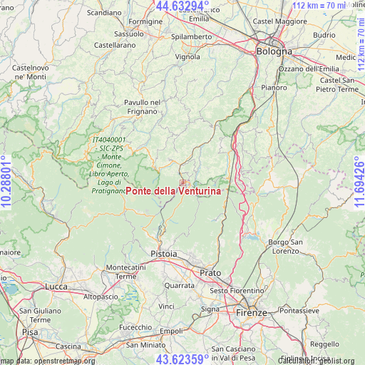
| Map corner | latitude | longitude |
|---|---|---|
| Upper-left | 44.63294°, | 10.28801° |
| Center: | 44.13042°, | 10.99113° |
| Lower-right: | 43.62359°, | 11.69426° |
| Map W x H: | 112.2×112.2 km | = 69.7×69.7mi |
| max Lat: | 47.04031° ⇑53.4% North |
| Ponte della Venturina: | 44.13042° |
| min Lat: | ⇓46.6% South 35.50142° |
| min Long | Ponte della Ven | max Long |
| 6.69888° | 10.99113° | 18.48682° |
| W 42.5%⇐ | ⇒57.5% E |
Elevation
Elevation of Ponte della Venturina is 413 m = 1355 ft, and this is 106.3 m = 349 ft above average elevation for this country.
| Max E: |
2085 m = 6841 ft | 28.2% |
| Ponte della Venturina | 413 m 1355 ft | |
| Avg. | 306.7 m = 1006 ft | |
Min E: |
-4 m = -13 ft | 71.8% |
See also: Italy elevation on elevation.city.
Geographical zone
Ponte della Venturina is located in North temperate zone (between Tropic of Cancer and the Arctic Circle). Distance of this Northern Tropic circle is 2300.9 km =1429.7 mi to South.| Distance of | km | miles | from Ponte della Venturina |
|---|---|---|---|
| North Pole | 5100.2 | 3169.1 | to North |
| Arctic Circle | 2494.3 | 1549.9 | to North |
| Tropic Cancer | 2300.9 | 1429.7 | to South |
| Equator | 4906.8 | 3048.9 | to South |


Nearby cities:
15 places around Ponte della Venturina: (largest is in red/bold)
• Berzantina
3.2 km =2 mi,  344°
344°
• Camugnano
9 km =5.6 mi,  59°
59°
• Cantagallo
14 km =8.7 mi,  149°
149°
• Castel di Casio
5 km =3.1 mi,  44°
44°
• Castiglione dei Pepoli
13.6 km =8.5 mi,  84°
84°
• Gaggio Montano
8.5 km =5.3 mi,  328°
328°
• Lizzano in Belvedere
8.5 km =5.3 mi,  293°
293°
• Marano
11.3 km =7 mi,  18°
18°
• Molino del Pallone
4.1 km =2.5 mi,  215°
215°
• Montepiano
14.2 km =8.8 mi,  108°
108°
• Porretta Terme
3.9 km =2.4 mi, 339°
• Riola
12.3 km =7.6 mi,  25°
25°
• Sambuca Pistoiese
3 km =1.9 mi,  166°
166°
• Silla
6 km =3.7 mi,  347°
347°
• Vidiciatico
10.2 km =6.3 mi,  295°
295°
Sources, notices
• [Note1] Compared only with cities in Italy existing in our database
• [Src1] Map data: © OpenStreetMap contributors (CC-BY-SA)
• [Src2] Other city data from geonames.org with taken over terms of usage.
• [Src3] Geographical zone / Annual Mean Temperature by Robert A. Rohde @ Wikipedia
