Silanus geodata
Silanus (Sardinia) is a seat of a third-order administrative division; located in Italy in Europe/Rome (GMT+2) time zone. With population of 2,092 people, there are 4000 cities with bigger population in this country. Compared to other cities in Italy, 85.7% of cities are located further ↑North; 82.9% of cities are located further →East and 71.5% of cities have lower elevation than Silanus. Note1


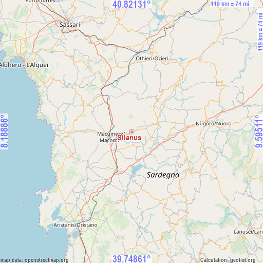
Silanus GPS coordinates[2]
40° 17' 13.524" North, 8° 53' 31.164" East
| Map corner | latitude | longitude |
|---|---|---|
| Upper-left | 40.82131°, | 8.18886° |
| Center: | 40.28709°, | 8.89199° |
| Lower-right: | 39.74861°, | 9.59511° |
| Map W x H: | 119.3×119.3 km | = 74.1×74.1mi |
| max Lat: | 47.04031° ⇑85.7% North |
| Silanus: | 40.28709° |
| min Lat: | ⇓14.3% South 35.50142° |
| min Long | Silanus | max Long |
| 6.69888° | 8.89199° | 18.48682° |
| W 17.1%⇐ | ⇒82.9% E |
Elevation
Elevation of Silanus is 410 m = 1345 ft, and this is 103.3 m = 339 ft above average elevation for this country.
| Max E: |
2085 m = 6841 ft | 28.5% |
| Silanus | 410 m 1345 ft | |
| Avg. | 306.7 m = 1006 ft | |
Min E: |
-4 m = -13 ft | 71.5% |
See also: Italy elevation on elevation.city.
Geographical zone
Silanus is located in North temperate zone (between Tropic of Cancer and the Arctic Circle). Distance of this Northern Tropic circle is 1873.6 km =1164.2 mi to South.| Distance of | km | miles | from Silanus |
|---|---|---|---|
| North Pole | 5527.6 | 3434.7 | to North |
| Arctic Circle | 2921.7 | 1815.5 | to North |
| Tropic Cancer | 1873.6 | 1164.2 | to South |
| Equator | 4479.5 | 2783.4 | to South |


Nearby cities:
15 places around Silanus: (largest is in red/bold)
• Aidomaggiore
13.2 km =8.2 mi,  193°
193°
• Birori
6.9 km =4.3 mi,  250°
250°
• Bolotana
7.2 km =4.5 mi,  54°
54°
• Borore
10.9 km =6.8 mi,  223°
223°
• Bortigali
4.5 km =2.8 mi,  263°
263°
• Bottidda
15.4 km =9.6 mi,  40°
40°
• Burgos
14.5 km =9 mi, 37°
• Dualchi
6.4 km =4 mi,  176°
176°
• Esporlatu
13.6 km =8.5 mi, 37°
• Illorai
11.8 km =7.3 mi, 51°
• Lei
3.1 km =1.9 mi, 46°
• Macomer
10.9 km =6.8 mi, 255°
• Noragugume
7.4 km =4.6 mi,  161°
161°
• Ottana
14.2 km =8.8 mi,  114°
114°
• Sedilo
12.9 km =8 mi,  169°
169°
Sources, notices
• [Note1] Compared only with cities in Italy existing in our database
• [Src1] Map data: © OpenStreetMap contributors (CC-BY-SA)
• [Src2] Other city data from geonames.org with taken over terms of usage.
• [Src3] Geographical zone / Annual Mean Temperature by Robert A. Rohde @ Wikipedia
