Ottana geodata
Ottana (Sardinia) is a seat of a third-order administrative division; located in Italy in Europe/Rome (GMT+2) time zone. With population of 2,307 people, there are 3751 cities with bigger population in this country. Compared to other cities in Italy, 86.2% of cities are located further ↑North; 80.6% of cities are located further →East and 57% of cities have higher elevation than Ottana. Note1


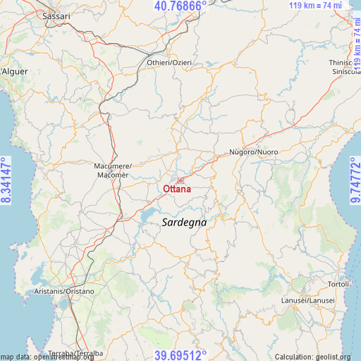
Ottana GPS coordinates[2]
40° 14' 2.472" North, 9° 2' 40.524" East
| Map corner | latitude | longitude |
|---|---|---|
| Upper-left | 40.76866°, | 8.34147° |
| Center: | 40.23402°, | 9.04459° |
| Lower-right: | 39.69512°, | 9.74772° |
| Map W x H: | 119.4×119.4 km | = 74.2×74.2mi |
| max Lat: | 47.04031° ⇑86.2% North |
| Ottana: | 40.23402° |
| min Lat: | ⇓13.8% South 35.50142° |
| min Long | Ottana | max Long |
| 6.69888° | 9.04459° | 18.48682° |
| W 19.4%⇐ | ⇒80.6% E |
Elevation
Elevation of Ottana is 188 m = 617 ft, and this is 118.7 m = 389 ft below average elevation for this country.
| Max E: |
2085 m = 6841 ft | 57% |
| Avg. | 306.7 m = 1006 ft | |
| Ottana | 188 m = 617 ft | |
Min E: |
-4 m = -13 ft | 43% |
See also: Italy elevation on elevation.city.
Geographical zone
Ottana is located in North temperate zone (between Tropic of Cancer and the Arctic Circle). Distance of this Northern Tropic circle is 1867.7 km =1160.5 mi to South.| Distance of | km | miles | from Ottana |
|---|---|---|---|
| North Pole | 5533.5 | 3438.4 | to North |
| Arctic Circle | 2927.6 | 1819.1 | to North |
| Tropic Cancer | 1867.7 | 1160.5 | to South |
| Equator | 4473.6 | 2779.8 | to South |


Nearby cities:
15 places around Ottana: (largest is in red/bold)
• Bidonì
16.3 km =10.1 mi,  214°
214°
• Bolotana
12.3 km =7.6 mi,  324°
324°
• Dualchi
12.5 km =7.8 mi,  267°
267°
• Gavoi
15.1 km =9.4 mi,  122°
122°
• Illorai
13.7 km =8.5 mi,  344°
344°
• Lei
13.4 km =8.3 mi,  306°
306°
• Noragugume
10.6 km =6.6 mi,  264°
264°
• Ollolai
13.5 km =8.4 mi, 122°
• Olzai
10.4 km =6.5 mi, 123°
• Oniferi
11.5 km =7.1 mi,  68°
68°
• Orani
11.8 km =7.3 mi,  80°
80°
• Orotelli
10.4 km =6.5 mi,  38°
38°
• Sarule
10.4 km =6.5 mi,  93°
93°
• Sedilo
12.6 km =7.8 mi,  237°
237°
• Silanus
14.2 km =8.8 mi,  294°
294°
Sources, notices
• [Note1] Compared only with cities in Italy existing in our database
• [Src1] Map data: © OpenStreetMap contributors (CC-BY-SA)
• [Src2] Other city data from geonames.org with taken over terms of usage.
• [Src3] Geographical zone / Annual Mean Temperature by Robert A. Rohde @ Wikipedia
