Sgonico geodata
Sgonico (Friuli Venezia Giulia) is a seat of a third-order administrative division; located in Italy in Europe/Rome (GMT+2) time zone. With population of 200 people, there are 11136 cities with bigger population in this country. Compared to other cities in Italy, 82.9% of cities are located further ↓South; 76.1% of cities are located further ←West and 56.2% of cities have lower elevation than Sgonico. Note1
Administrative division(s):
- Level 1: Friuli Venezia Giulia
- Level 2: Provincia di Trieste
- Level 3: Sgonico


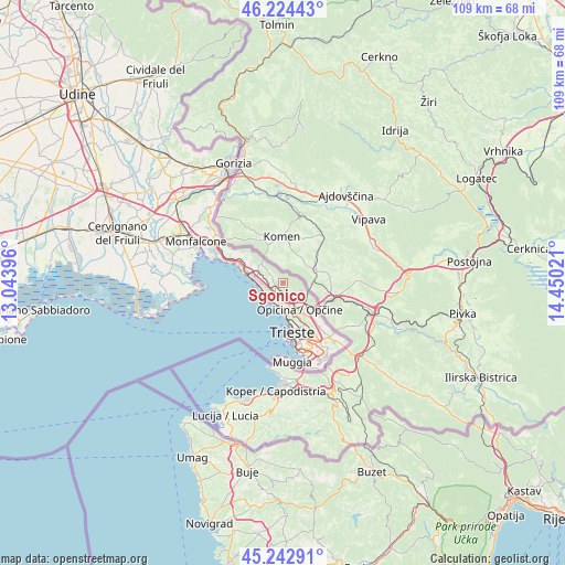
Sgonico GPS coordinates[2]
45° 44' 8.988" North, 13° 44' 49.488" East
| Map corner | latitude | longitude |
|---|---|---|
| Upper-left | 46.22443°, | 13.04396° |
| Center: | 45.73583°, | 13.74708° |
| Lower-right: | 45.24291°, | 14.45021° |
| Map W x H: | 109.1×109.1 km | = 67.8×67.8mi |
| max Lat: | 47.04031° ⇑17.1% North |
| Sgonico: | 45.73583° |
| min Lat: | ⇓82.9% South 35.50142° |
| min Long | Sgonico | max Long |
| 6.69888° | 13.74708° | 18.48682° |
| W 76.1%⇐ | ⇒23.9% E |
Elevation
Elevation of Sgonico is 273 m = 896 ft, and this is 33.7 m = 111 ft below average elevation for this country.
| Max E: |
2085 m = 6841 ft | 43.8% |
| Avg. | 306.7 m = 1006 ft | |
| Sgonico | 273 m = 896 ft | |
Min E: |
-4 m = -13 ft | 56.2% |
See also: Italy elevation on elevation.city.
Geographical zone
Sgonico is located in North temperate zone (between Tropic of Cancer and the Arctic Circle). Distance of this North polar circle is 2315.8 km =1439 mi to North.| Distance of | km | miles | from Sgonico |
|---|---|---|---|
| North Pole | 4921.7 | 3058.2 | to North |
| Arctic Circle | 2315.8 | 1439 | to North |
| Tropic Cancer | 2479.4 | 1540.6 | to South |
| Equator | 5085.3 | 3159.9 | to South |


Nearby cities:
15 places around Sgonico: (largest is in red/bold)
• Aurisina
5.9 km =3.7 mi,  285°
285°
• Aurisina Cave
7.1 km =4.4 mi, 286°
• Basovizza
13.8 km =8.6 mi,  139°
139°
• Domio
15.4 km =9.6 mi,  154°
154°
• Duino
11.8 km =7.3 mi, 290°
• Muggia
14.7 km =9.1 mi,  173°
173°
• Padriciano
11.2 km =7 mi, 140°
• Prosecco-Contovello
3.3 km =2.1 mi,  198°
198°
• Repen
3.7 km =2.3 mi,  112°
112°
• Santa Croce
4.2 km =2.6 mi,  268°
268°
• Sistiana-Visogliano
9.4 km =5.8 mi,  295°
295°
• Trebiciano
9.3 km =5.8 mi, 139°
• Trieste
9.9 km =6.2 mi, 166°
• Villa Opicina
6.2 km =3.9 mi, 148°
• Zolla
5.3 km =3.3 mi, 113°
Sources, notices
• [Note1] Compared only with cities in Italy existing in our database
• [Src1] Map data: © OpenStreetMap contributors (CC-BY-SA)
• [Src2] Other city data from geonames.org with taken over terms of usage.
• [Src3] Geographical zone / Annual Mean Temperature by Robert A. Rohde @ Wikipedia
