Sezze geodata
Sezze (Latium) is a seat of a third-order administrative division; located in Italy in Europe/Rome (GMT+2) time zone. With population of 16,071 people, there are 566 cities with bigger population in this country. Compared to other cities in Italy, 74.8% of cities are located further ↑North; 69% of cities are located further ←West and 60.6% of cities have lower elevation than Sezze. Note1


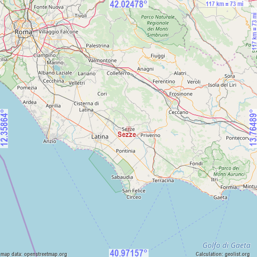
Sezze GPS coordinates[2]
41° 30' 1.152" North, 13° 3' 42.336" East
| Map corner | latitude | longitude |
|---|---|---|
| Upper-left | 42.02478°, | 12.35864° |
| Center: | 41.50032°, | 13.06176° |
| Lower-right: | 40.97157°, | 13.76489° |
| Map W x H: | 117.1×117.1 km | = 72.8×72.8mi |
| max Lat: | 47.04031° ⇑74.8% North |
| Sezze: | 41.50032° |
| min Lat: | ⇓25.2% South 35.50142° |
| min Long | Sezze | max Long |
| 6.69888° | 13.06176° | 18.48682° |
| W 69%⇐ | ⇒31% E |
Elevation
Elevation of Sezze is 304 m = 997 ft, and this is 2.7 m = 9 ft below average elevation for this country.
| Max E: |
2085 m = 6841 ft | 39.4% |
| Avg. | 306.7 m = 1006 ft | |
| Sezze | 304 m = 997 ft | |
Min E: |
-4 m = -13 ft | 60.6% |
See also: Italy elevation on elevation.city.
Geographical zone
Sezze is located in North temperate zone (between Tropic of Cancer and the Arctic Circle). Distance of this Northern Tropic circle is 2008.5 km =1248 mi to South.| Distance of | km | miles | from Sezze |
|---|---|---|---|
| North Pole | 5392.7 | 3350.9 | to North |
| Arctic Circle | 2786.8 | 1731.6 | to North |
| Tropic Cancer | 2008.5 | 1248 | to South |
| Equator | 4614.4 | 2867.3 | to South |


Nearby cities:
15 places around Sezze: (largest is in red/bold)
• Bassiano
6.4 km =4 mi,  333°
333°
• Borgo Faiti
6.4 km =4 mi,  233°
233°
• Borgo San Michele
10.1 km =6.3 mi, 226°
• Carpineto Romano
11.8 km =7.3 mi,  9°
9°
• Carrara-Pontenuovo
10 km =6.2 mi,  296°
296°
• Latina Scalo
10.3 km =6.4 mi,  289°
289°
• Maenza
10.5 km =6.5 mi,  75°
75°
• Monticchio
8.4 km =5.2 mi, 301°
• Norma
12.2 km =7.6 mi,  321°
321°
• Pontinia
10.1 km =6.3 mi,  189°
189°
• Priverno
10.3 km =6.4 mi,  108°
108°
• Roccagorga
8.2 km =5.1 mi,  70°
70°
• Scopeto Madonna Gulia
11.9 km =7.4 mi,  224°
224°
• Sermoneta
8.4 km =5.2 mi,  310°
310°
• Sezze Scalo
1.6 km =1 mi,  257°
257°
Sources, notices
• [Note1] Compared only with cities in Italy existing in our database
• [Src1] Map data: © OpenStreetMap contributors (CC-BY-SA)
• [Src2] Other city data from geonames.org with taken over terms of usage.
• [Src3] Geographical zone / Annual Mean Temperature by Robert A. Rohde @ Wikipedia
